Arizona
1 - 5 days
3 day
itinerary in
Grand Canyon
1½-Mile Resthouse
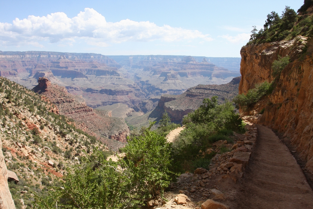
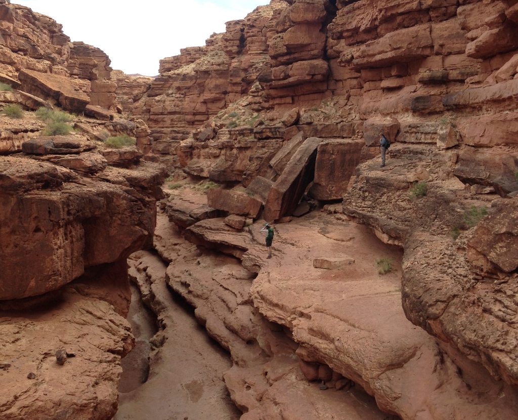
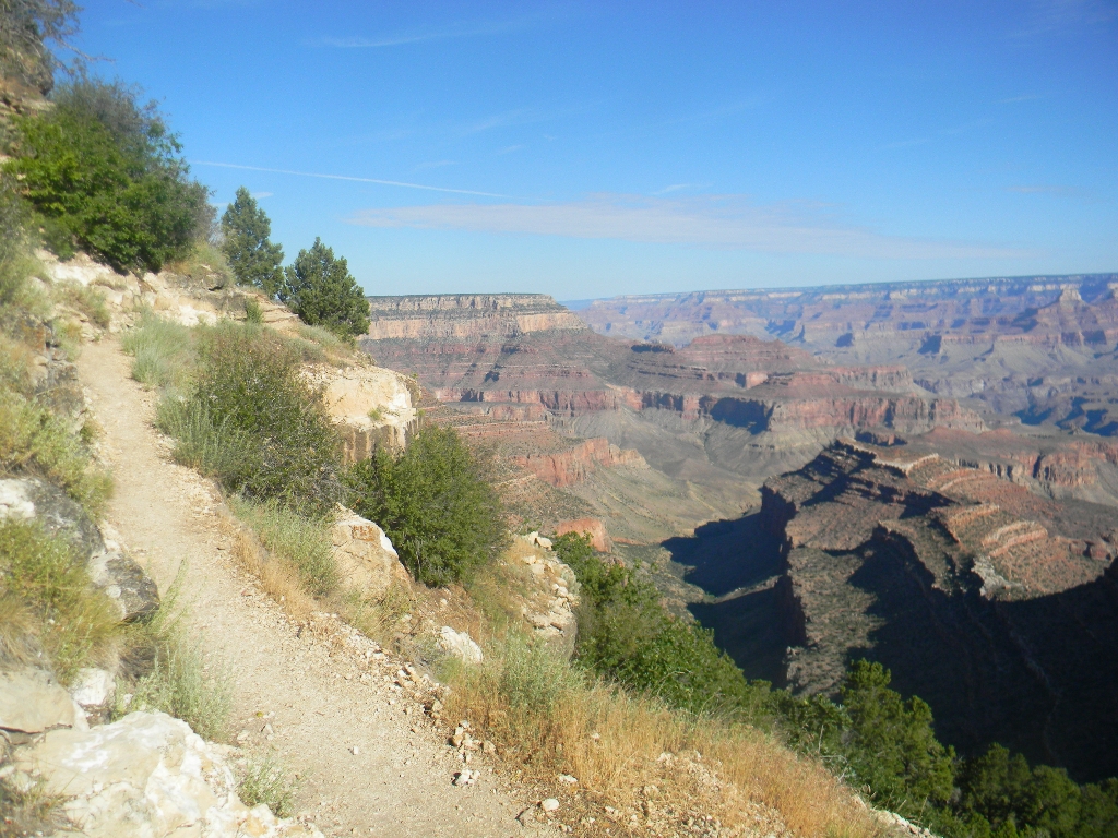
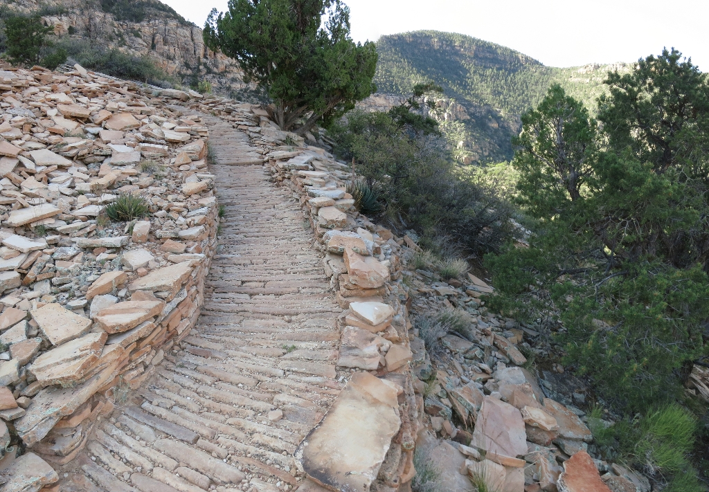
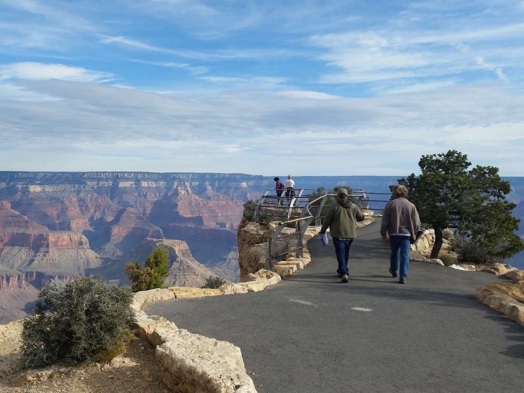
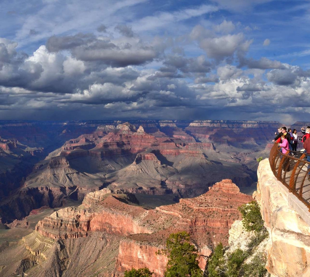
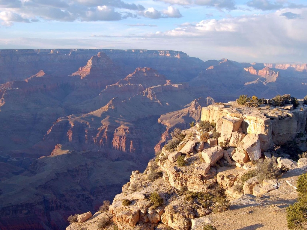
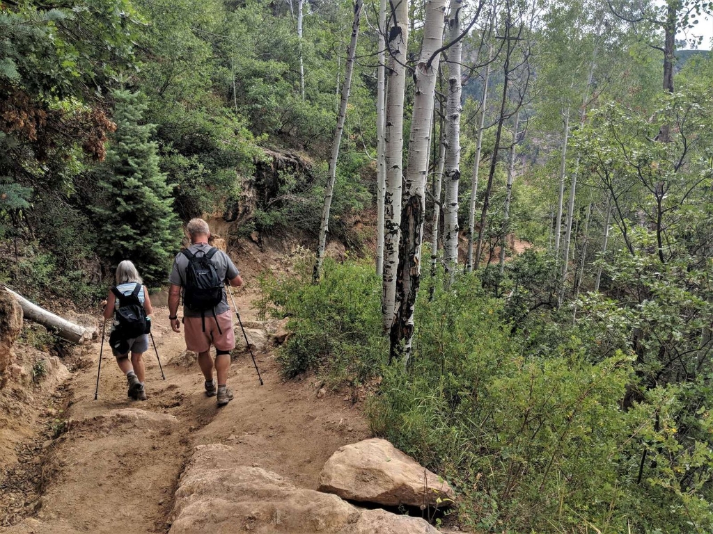
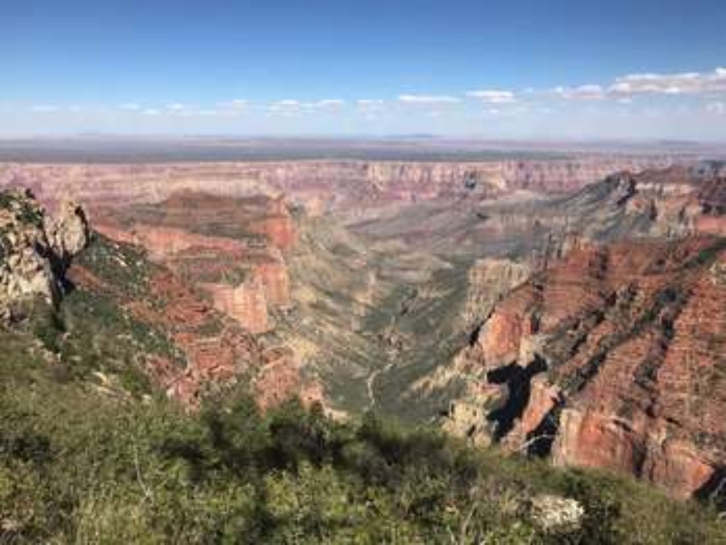
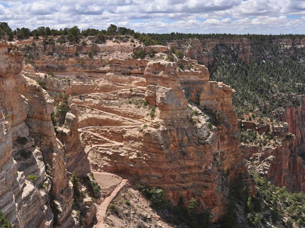
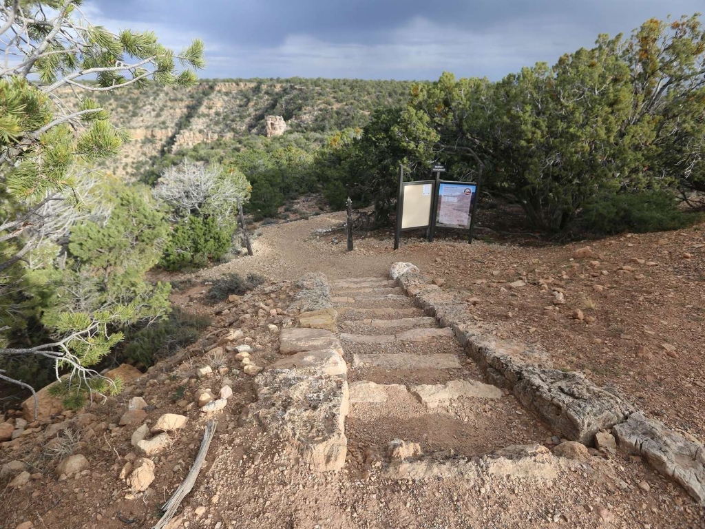
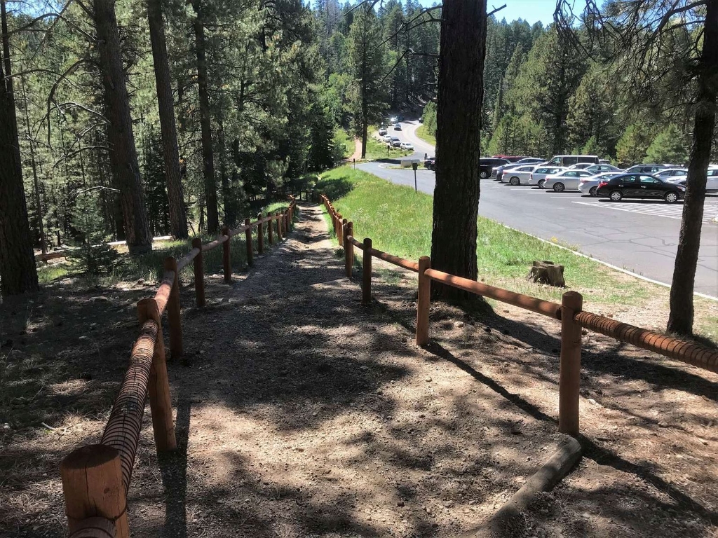
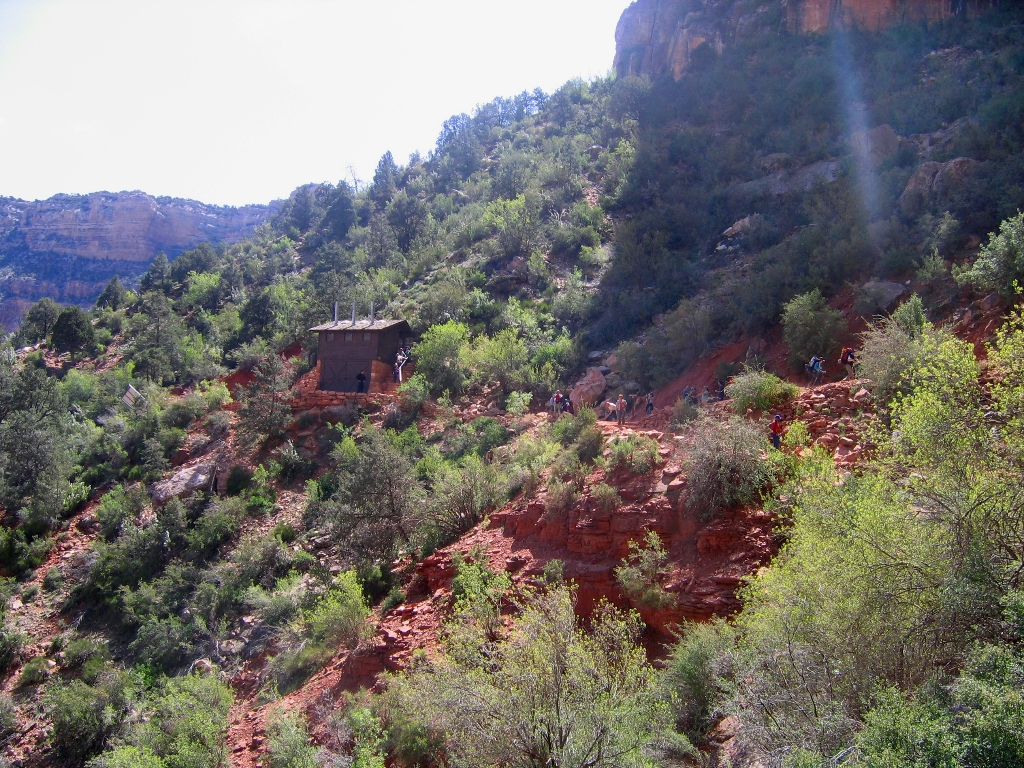
Popular day-hike destination with vault toilets and potable water.
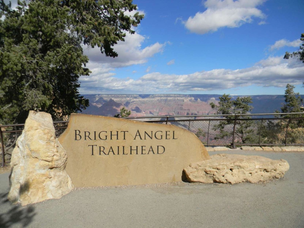
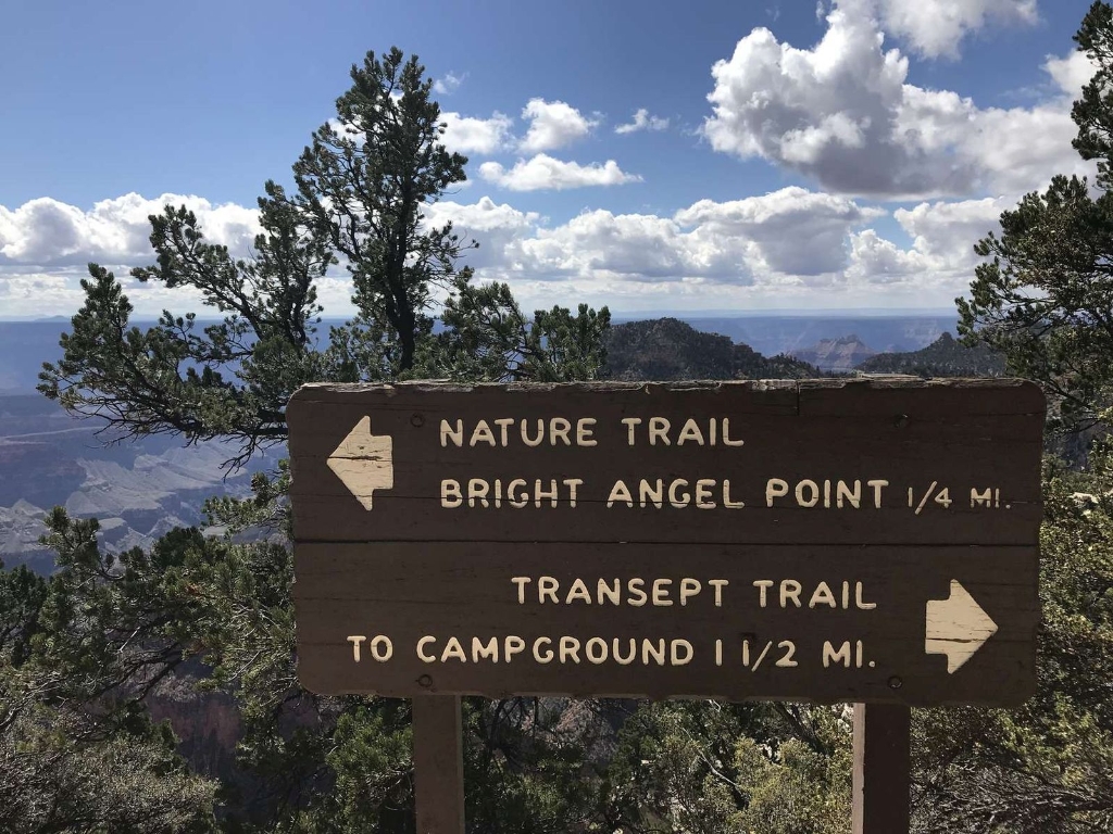
This popular day-hike destination along Bright Angel Trail provides relief from the weather and extremes of all seasons. Vault toilets are available year-round. During the summer months, this location is a good source for potable water. Just over 1,100 feet (335 m) below Grand Canyon's rim, this first rest area offers visitors a taste of the struggles and rewards Grand Canyon's steep trails present.
Angels Window
Short trail to viewpoint above Angels Window, stunning views, secure area.
A short, easy side trail from the Cape Royal trail leads to an area above Angels Window, which offers visitors the chance to stand over a natural arch and enjoy a magnificent viewpoint. The views are stunning and one may feel as if they are floating above the canyon. Railings and fencing secure the area. However, walking above Angels Window may not be a good idea if you are afraid of heights!
Animal Life Appeared About 630 Million Years Ago
Grand Canyon rocks hold ancient life tales, fossils, tracks decoded.
The record of life and the stories of the diverse creatures that once lived here are captured in the rocks that make up the walls and cliffs of Grand Canyon today in the form of fossils, tracks, and various clues deciphered by paleontologists.
Arizona Steakhouse (at Bright Angel Lodge)
Arizona Steak House CLOSED for winter - Jan 2 - Mar 3. Lunch 11:30 am - 3:00 pm, Dinner 4:30 pm - 9:30 pm.
The Arizona Steak House (at Bright Angel Lodge) CLOSED FOR THE WINTER - January 2, through March 3, 2024. – Lunch 11:30 am – 3:00 pm, Dinner 4:30 pm – 9:30 pm. Located on the east side of Bright Angel Lodge in the South Rim Village Historic District, the Arizona Steakhouse is one of the few restaurants in the park offering canyon views from the dining area. Southwestern flavors and ingredients inspire the cuisine.
Arizona Trail
Arizona Trail. Connects North Entrance to North Kaibab Trail, 10 miles.
The Arizona Trail is an ambitious project that traverses the length of Arizona from the Utah border to Mexico. A section of this trail enters the park near the North Entrance and roughly parallels the highway until it connects with the North Kaibab Trail, a distance of approximately 10 miles (16 km).
Backcountry Information Center
Backcountry Info Center open daily, 8 am–5 pm. Take shuttle.
The Backcountry Info Center is open daily from 8 am–noon; and 1 pm–5 pm, and provides information, permits, and trip planning assistance about day and overnight hikes into the canyon. The building is located in the village by Parking Lot D, and across the railroad tracks from Maswik Lodge. Park in Lot D, then take the free, early morning Hikers' Express bus from Backcountry Info Center to South Kaibab Trailhead.
Backcountry Information Center - Village (Blue) Route
Parking Lot D: 150 standard spaces, 30 for RVs/buses; restrooms, water, trail info. Hikers' Express shuttle bus, South Kaibab Trailhead stop, waterline construction.
Parking Lot D has 150 standard parking spaces, and 30 sized for RVs or buses. The Backcountry Information Center provides restrooms, water, trail information, and helpful park rangers ready to answer your questions and help plan your trip. The early morning Hikers' Express shuttle bus also stops here daily on its way to the South Kaibab Trailhead. NOTE: Bright Angel Trail is closed for waterline construction between December 1, 2023, and April 14, 2024.
Bridle Path (North End)
Trail following road, connects Lodge with Campground, Info Center, Trailhead. 1.9 miles.
This trail follows the road (AZ 67) and connects Grand Canyon Lodge with the North Rim Campground, the Backcountry Information Center, and North Kaibab Trailhead. It is 1.9 miles through the forest, with minimal elevation gain. Bicycles and leashed pets are permitted on this hard-packed trail.
Bridle Path (South End)
Trail connects lodge, campground, info center, trailhead. 1.9 miles, minimal elevation gain.
This trail follows the road (67) and connects Grand Canyon Lodge with the North Rim Campground, the Backcountry Information Center, and North Kaibab Trailhead. It is 1.9 miles through the forest, with minimal elevation gain. Bicycles and leashed pets are permitted on this hard-packed trail.
Bright Angel Bicycles & Café —Visitor Center Plaza
South Rim Visitor Center Plaza. Café, bike rentals, guided tours.
Located in the South Rim Visitor Center's Plaza, adjacent to Parking Lot 4. Hours: Bicycle Rentals/Tours: 10 am to 4 pm (weather permitting). Café: 8 am to 5 pm. Bright Angel Bicycles & Café offers bicycle rentals and guided tours, as well as a full espresso bar and grab-and-go sandwiches, salads, pastries, drinks, and more. Open daily during the winter months.
Bright Angel Fault Fossil Beds
Exploring Grand Canyon's rock layers reveals ancient marine life fossils.
Thousands of feet of exposed rock layers at Grand Canyon provide a veritable playground for scientists to explore and this site tells the tale of a world far different than the one we see here today. With careful eyes the exposed fossilized remains of creatures from an ancient marine environment can be seen.
Bright Angel Lodge
Bright Angel Lodge dining options, open daily from early morning.
Opened in 1935, Bright Angel Lodge offers several dining options: Bright Angel Fountain/Coffee and Grab and Go: 6 am to 3 pm daily. Fred Harvey Burger: Breakfast: 7 to 10:30 am, lunch: 11 am to 3 pm, dinner: 4 to 9 pm daily. Fred Harvey Tavern: 11 am to 10 pm daily. Arizona Steakhouse: Lunch: 11:30 am to 3 pm, Dinner: 4:30 pm to 9:30 pm. daily. The lodge is located right along the canyon's edge in the historic district.
Bright Angel Lodge - Village (Blue) Route
Shuttle stop near lodges, canyon rim access, Hikers' Express service.
Located on Village Loop Road and just east of Bright Angel Lodge, this shuttle stop offers quick access to the canyon rim. Thunderbird and Kachina lodges (guest rooms) and Bright Angel Lodge (including Fred Harvey Burger, Bright Angel Coffee Bar and Fountain). The early morning Hikers' Express Shuttle, with service to South Kaibab Trailhead, also departs daily from this stop.
Bright Angel Point
Popular viewpoint accessed from lodge area for short hike.
The most popular viewpoint on the North Rim is accessed from a steeply paved trail below Grand Canyon Lodge. Just a quarter-mile from the lodge area, it is often the first hike visitors do when they arrive at the North Rim.
Bright Angel Point Trail
Narrow paved path with steep sections, spectacular views, dangers.
This narrow, paved path provides spectacular views, though it drops off dramatically on both sides in some places, and certain sections are surprisingly steep.
Bright Angel Trail
Bright Angel Trail closed 12/1/23 - 4/14/24, 1/2 mile detour.
BRIGHT ANGEL TRAIL - IS CLOSED - 1/2 mile from the Trailhead down to the Silver Bridge, including Havasupai Gardens Campground. CLOSURE DURATION: December 1, 2023, through April 14, 2024. Bright Angel Trail lets hikers walk in the footsteps of the canyon's Indigenous Peoples, miners, and early tourists, as they descend into the canyon's depths. Offering big views, morning and afternoon shade, resthouses, vault toilets, and water stations during the summer.
Bright Angel Trailhead
Bright Angel Trailhead near lodges in Grand Canyon accessible by shuttle.
Bright Angel Trailhead is located just west of Bright Angel Lodge, Lookout Studio, and Kolb Studio. At 6,840 feet (2,085 m), it provides access for hikers and mules to many inner canyon destinations. From the Hermit Road Interchange shuttle bus stops, it is a short walk to the east, and up a hill, on a paved footpath to the trailhead. 
Buckey O'Neill Cabin
Only remaining pioneer cabin, built in 1895 by Buckey.
This cabin is the only remaining building from the early pioneer settlement era of the Village. Built on this site in 1895 by William Owen "Buckey" O'Neill, the 2-room office and bunkhouse—complete with v-notched logs, rough mortar chinking, and a native stone chimney—was the rustic home of Buckey and his wife while they operated a small hotel on the South Rim.
Buggeln Picnic Area
Buggeln picnic area with shade, toilets, tables; no canyon view.
The Buggeln picnic area features vault toilets, multiple picnic tables, shade, and exhibit panels describing the local forest habitat; no water. There is no direct view of the canyon from this site, but a few small glimpses can be seen through the gaps in the trees. The small, teardrop-shaped parking area is fine for cars and small RVs, but larger vehicles and those towing trailers will find turning around a bit tight.
Camper Services — Laundry and Showers
Camper Services near campground entrance. Fall hours 7 am-6 pm.
Camper Services (Laundry and Showers) is located near the entrance to Mather Campground. Fall Hours of Operation 7 am to 6 pm daily. Last laundry load: 4:30 pm — Last shower: 5:45 pm. Camper Store is closed for the season. Adjacent to Camper Services is a free dump station and potable water filling station for RVs. Several picnic tables are located outside the building.
Canyon Village Market & Deli
Canyon Village Market & Deli, open 7 am-8 pm daily.Groceries, souvenirs, outdoor gear.
Canyon Village Market & Deli is located in Market Plaza, across the parking lot from Yavapai Lodge and next to the US Post Office. The Market/General Store is open daily from 7 am to 8 pm. The Deli is open daily from 7 am to 8 pm. (Spring 2023 hours) A large selection of groceries and souvenirs are available, along with outdoor gear for campers and backpackers.
Cape Final
Named by geologist, scenic viewpoint, rewards hikers with unique views.
Named by geologist Clarence Dutton in 1880, this scenic viewpoint rewards hikers for their 4-mile (6.4 km) round-trip hike with unique, spectacular views of the Painted Desert beyond Grand Canyon. According to Dutton, "Point Final is doubtless the most interesting spot on the Kaibab."
Cape Final Trail
Forest trail, 4.2-mile round trip to Cape Final viewpoint.
This relatively flat, forested trail leads hikers 2.1 miles (3.4 k) to the end of Cape Final, for a 4.2 miles (6.8 k) round trip hike. The trail begins at a dirt parking lot 2.4 miles (3.9 k) north of the Cape Royal parking lot. The first half of this rocky trail is entirely within the forest, but views of Grand Canyon begin peaking through the trees around the halfway mark. The trail comes to an end at Cape Final, one of the most spectacular viewpoints on the North Rim.
Cape Royal
Limited Colorado River views. Short wheelchair-accessible path from southeast parking. Picnic area on west side.
Cape Royal and Angel's Window are some of the only spots with views of the Colorado River from the North Rim. From the southeast side of the parking lot, a short wheelchair-accessible path leads to several spectacular viewpoints. The west side of the parking lot is where you can find a picnic area.
Cape Royal Road
Scenic drive to viewpoints and trails, including Point Imperial, Cape Royal.
Cape Royal Road is a fantastic scenic drive leading to various points of interest, including Point Imperial and Cape Royal .Diverse viewpoints and several trails can be reached via this winding scenic drive.
Cathedral Wash at Lees Ferry
Trailhead for Cathedral Wash hike, walking time not specified.
Trailhead for Cathedral Wash hike
CCC Legacy and Transcanyon Line Monument
Civilian Conservation Corp workers built transcanyon telephone line in 1935.
Many of our national parks have benefited from the hard work of the Civilian Conservation Corp (CCC) and Grand Canyon is no different. This site marks where CCC workers built the transcanyon telephone line in 1935.
Center Road - Village (Blue) Route
Bus stop accesses Parking Lot C, central to historic district.
This bus stop along the Village (Blue) Route provides direct access to Parking Lot C, a small public lot with 38 spaces, but often one of the last parking areas to fill during busy days. This stop is centrally located within the historic district of Grand Canyon Village with historic buildings located to the east, north and west of this point.
Cliff Spring Trail
Trail access from pullout, 0.5 km from Cape Royal. Walk down ravine.
This short, unique trail is accessed from a pullout on the left side of a curve in the road, 0.3 miles (0.5 km) from Cape Royal. The trail heads down along a wash down into a forested ravine.
Deli in the Pines
Deli in the Pines closed for winter, reopens May 15, 2024.
Closed for the Winter - Deli in the Pines is scheduled to reopen on May 15, 2024. Hours of operation: 10 am to 9 pm daily. Deli in the Pines is located in the main lodge building. Coffee drinks are available daily in addition to grab-and-go sandwiches, pizza, soup/chili and snacks. For convenience, all items are available for takeout dining —perfect for a picnic or during a hike.
Desert View Amphitheater
Summer 2024: Sunset Talks on Mon, Tue, Wed at amphitheater.
During the Summer of 2024, Sunset Talks by park rangers will take place at the amphitheater on Monday, Tuesday and Wednesday.  Enjoy a program with a beautiful sunset backdrop. The talks start an hour before sunset, and end with enough time to take pictures and enjoy the view.  The Amphitheater is also the location of the Grand Canyon Speaks presentations, in which members of Grand Canyon's 11 Tribal Communities share their rich history and culture.
Desert View Entrance Station
Desert View Entrance Station location, ideal for motorists from Southwest.
Approximately 30 miles (48 km) west of Cameron, AZ, and 23 miles (37 km) east of Grand Canyon Village, the Desert View Entrance Station serves as a secondary gateway to the South Rim and the primary portal to the Desert View area. It is open 24 hours/day, 7 days/week. This entrance is ideal for motorists traveling to/from Southwestern Colorado, Southern Utah, New Mexico and Phoenix, Arizona.
Desert View Gas Station
Self-service fuel available 24/7; store open 9-5. Walking time: N/A.
Self-service gasoline and diesel fuel (pay at the pump with credit or debit card) is available year-round, 24 hours a day. The convenience store is open from 9 am to 5 pm daily. The park's only gas station on the South Rim offers visitors one last chance to fill-up before heading to the next closest gas stations 30 miles (48 km) east in the town of Cameron, Arizona —or 30 miles (48 km) west in the town of Tusayan, Arizona (just outside of the park's south entrance).
Desert View Market & Deli
Market near Desert View settlement; groceries, souvenirs; deli open.
Located on the eastern side of the Desert View settlement, near the restrooms, the market sells groceries and souvenirs, including t-shirts, keychains and coffee mugs. Current hours of operation are from 9 am to 5 pm daily. The deli, inside the market, is open from 10 am to 5 pm daily. There is both indoor and outdoor seating. Stock up on groceries for camping, or road trip snacks and drinks.
Desert View Point and 1956 Aviation Memorial
Colorado River makes 90-degree turn at Desert View Point.
Below Desert View Point, the Colorado River makes a sharp 90-degree turn to the west, cutting directly into a major uplift. Looking to the west, one can glimpse in the distance where the river plunges into the black, narrow, confined depths of the Granite Gorge. Also at Desert View Point, a plaque and stone memorial commemorate the 1956 Grand Canyon TWA-United Airlines Aviation Accident Site, a horrific airline collision over Grand Canyon that took place on June 30, 1956.
Desert View Trading Post
Trading Post near canyon offers crafts, snacks, 9am-5pm daily.
Within sight of Desert View Point and the Watchtower, the Trading Post is just up the walkway from the rim of the canyon. Hours are 9 am to 5 pm daily. A snack bar is located inside the Trading Post. It offers ice cream, sweet treats and coffee drinks. There is an outdoor patio. When it comes to authentic Native American crafts, the trading post gallery/shop features handicrafts from Grand Canyon's associated tribes.
Desert View Watchtower
Desert View Watchtower Retail Store open daily 8 am - 6 pm.
Desert View Watchtower Retail Store (View Room) is open daily: 8 am to 6 pm. The upper floors of the tower are open most days from 8:20 am to 4:40 pm. There is ticketed entry - follow the link for details. A National Historic Landmark, the Watchtower was constructed in 1932.The design by Mary Colter, is based on the architecture of the Ancestral Puebloan people of the Southwest. Cultural handicraft demonstrations take place in the View Room during spring, summer and fall.
Duck on a Rock
Parking on Desert View Drive for Grand Canyon viewing spot.
This unsigned pull off on Desert View Drive offers plenty of parking for cars, larger vehicles, and RVs to stop and view Grand Canyon and a well-known rock formation.
Edge of Vastness Wayside
Grand Canyon's vastness put into perspective near Bright Angel Trail.
It can be hard to put into context how vast Grand Canyon is. Nestled between the Kolb Studio and the Bright Angel Trail, this wayside attempts to put it into perspective, while offering sweeping overlooks of the canyon itself.
El Tovar Hotel
El Tovar Hotel near Grand Canyon offers dining, lounge, gift shop.
Located directly on the rim of Grand Canyon, El Tovar Hotel features a fine dining room, lounge, gift shop, and newsstand. Dining Room - Breakfast: 6:30 am - 10 am, Lunch: 11 am - 2:30 pm, Dinner: 4:30 pm - 9:30 pm. *Advanced reservations are required for lunch and dinner at El Tovar Dining Room. (928) 638-2631 - El Tovar Lounge 11:30 am to 9:30 pm, El Tovar Patio (Limited Menu) 11 am to 8 pm.
El Tovar Monument
First modern hotel in Village, became heart of Grand Canyon.
The first modern hotel constructed in the Village, El Tovar Hotel eventually became the eventual heart of Grand Canyon National Park, and a National Historical Landmark. Constructed to the highest standards of the time, El Tovar Hotel helped lure visitors to a remote and rough canyon region.
Grand Canyon Conservancy
GCC funds Grand Canyon projects not supported by federal money.
Grand Canyon Conservancy (GCC) is the official nonprofit partner of Grand Canyon National Park, funding projects not covered by federal money.
Grand Canyon Conservancy Park Store in the North Rim Visitor Center
Park Store closed until May 15, 2024. Hours: 8 am to 6 pm.
Closed for the Winter - The Park Store is scheduled to reopen on May 15, 2024. Hours of operation: 8 am to 6 pm daily. Grand Canyon Conservancy's Park Store within the North Rim Visitor Center building features a wide variety of books, maps, and gifts to help you plan or remember your trip to Grand Canyon and to learn more about its geology, ecology, and history. Store employees can direct you to the nearby Ranger Roost, for additional information services.
Grand Canyon Conservancy Visitor Center Park Store
Store open 8am-7pm daily. Located south Grand Canyon Visitor Center.
Hours of Operation —Open 8 am to 7 pm daily. Located on the south side of Grand Canyon Visitor Center Plaza, adjacent to parking lot 4. This large store features books, maps, apparel, souvenirs, and gifts to help you plan, or share your trip to Grand Canyon with friends and family back home. A large variety of publications provide in-depth information about the canyon's geology —as well as natural and cultural history.
Grand Canyon Kennel
Kennel near Maswik Lodge offers pet boarding; reservations recommended.
Located on the South Rim near Maswik Lodge, Grand Canyon Kennel is operated by Xanterra, and accepts dogs and cats only. Reservations are highly recommended, especially during spring break and summer. The kennel is open 7:30 am – 5 pm, 7 Days/Week. Overnight boarding is available. The kennel can provide a safe place for your furry friend to stay while you explore all that Grand Canyon has to offer.
Grand Canyon Lodge
Grand Canyon Lodge closed for winter, reopens May 15, 2024.
Closed for the Winter. Grand Canyon Lodge is scheduled to reopen on May 15, 2024. Dining Room: (Breakfast 6:30 am to 10 am) Lunch 11:30 am to 2:30 pm. (Dinner 4:45 pm to 9:45 pm). The lodge features private cabins, both along and near the rim of Grand Canyon in the forest. Accommodations are very popular and typically book up a year in advance. Be sure to book your rooms before travelling to the park.
Grand Canyon Lodge Gift Shop
Gift shop closed. Reopens May 15, 2024, 8 am-9 pm daily.
Closed for the Winter. - The Gift Shop is scheduled to reopen on May 15, 2024 Hours of operation: 8 am to 9 pm daily. Located in the Grand Canyon Lodge building, the gift shop offers visitors to the North Rim postcards, along with gifts and souvenirs of their trip. From clothing and accessories to Native Americans handicrafts, the shop has something for everyone.
Grand Canyon National Park Headquarters
Park Headquarters closed; visitor center, hiking info, ranger programs available.
Park Headquarters is currently closed to the public. Between 1957 and 2001, this building was the South Rim Visitor Center. Basic trip planning and hiking information, along with ranger program schedules are posted on signs in front of the building. A paved footpath, just beyond the left side (southwest side) of the building reaches the canyon rim in 0.5 mile/ 0.8 km.
Grand Canyon Pioneer Cemetery
Grand Canyon Pioneer Cemetery near Shrine of the Ages.
Located next to Shrine of the Ages the Grand Canyon Pioneer Cemetery is the final resting place of many historical figures involved in the development and protection of Grand Canyon as a National Park. Captain John Hance, Ralph Cameron, Pete Berry, Ellsworth Kolb, Gunnar Widforss, and Eddie McKee are just a few of the folks you might visit here.
Grand Canyon South Entrance Station
South Entrance Station, primary entrance to Grand Canyon National Park.
The South Entrance Station is the entry point for most visitors to Grand Canyon National Park. It is the closest entrance to Grand Canyon Village on the South Rim. The entrance is open 24 hours/day and 7 days/week, unless closed by snow. Located in Arizona, it is 5 miles (8 km) north of the gateway town of Tusayan; 55 miles (89 km) north of Williams, Arizona via SR 64 from I-40; and 80 miles (129 km) north of Flagstaff via US 180,
Grand Canyon Visitor Center Shuttle Bus Terminal
Main hub for park's shuttle buses, various routes available. Tusayan route closed until Summer 2024.
This terminal is the main hub for the park's free shuttle buses. During spring, the Village (Blue) Route shuttle connects the Visitor Center Plaza with lodges, campgrounds, the Backcountry Information Center, and Market Plaza (supermarket, deli, outside ATM, and U.S. Post Office). The Kaibab Rim (Orange Route) eastbound to South Kaibab Trailhead, or westbound to Yavapai Geology Museum. The Tusayan (Purple) Route - Park & Ride shuttle is CLOSED. Service resumes, Summer 2024.
Grand Canyon's Rocks Are Incredibly Old
Grand Canyon is geologically young, rocks span 1.5 billion yrs.
Geologically speaking, the canyon is considered to be a "young" feature, having largely been eroded in just the last few million years. But the rocks of Grand Canyon are a different matter entirely. The age range of Grand Canyon's rocks encompasses over 1.5 billion years of Earth's past, from the oldest known rock, at an ancient 1.8 billion years old, to the youngest, a mere 270 million years old.
Grandeur Point
Location offers great canyon views, aerial views of Bright Angel Trail.
This location offers one of the better views of the layers and depths of the canyon in the area of Grand Canyon Village. It also provides especially fantastic aerial views of the switchbacks on the upper and middle portions of Bright Angel Trail.
Grandview Point
Popular viewpoint with panoramic Grand Canyon views, Colorado River bends, amenities.
This popular viewpoint offers panoramic views of Grand Canyon from east to west, including several bends of the Colorado River to the east, a restroom, a hiking trail, and parking for larger vehicles.
Grandview Trail
Ancient trail used by miners, rocky and strenuous, caution required.
First used by American Indians who gathered mineral paints on Horseshoe Mesa, and later by copper miners, the Grandview Trail is a rocky, exposed, strenuous trail requiring experience and caution. Big steps and extreme pitches intensify this hike.
HawkWatch Site
Migrating raptors fly through Grand Canyon in September, October.
In September and October, large concentrations of migrating raptors fly through Grand Canyon National Park on their migration routes through the 'Central Flyway'. This established migration corridor and avian conservation zone stretches from the upper reaches of Canada's boreal forests into Central and South America.
Hermit Road Transfer Station - Village (Blue) Route
Shuttle stop access to trails, historic village; 7.5-mile walking time.
This shuttle stop provides access to both the Bright Angel Trailhead and the first shuttle stop on the Hermit (Red) Route. During December, January and February, Hermit Road is open to private vehicles, and the Hermit Road Shuttle (Red) Route is not in service. Located at the western end of Grand Canyon Village, this shuttle stop also provides access to the historic village and the paved Canyon Rim Trail heading west along Hermit Road, 7.5 miles towards Hermits Rest.
Hermit Trail Grand Canyon
Hermit Trail, built in 1911 by Santa Fe Railroad.
The Hermit Trail was originally built by the Santa Fe Railroad in 1911 and provided access to the developed luxury Hermit Camp and Waldron Basin tourist areas. Today, the Hermit Trail still offers experienced, knowledgeable canyon backpackers a direct link to the excitement and romance of the early days at Grand Canyon.
Hermits Rest - Hermits Rest (Red) Route
Shuttle stop with amenities, water filling station, trails, canyon views.
The final shuttle stop on the Hermit Road (Red) Route, where shuttle buses turn around and begin their return trip back to the Village, Hermits Rest provides access to the only water bottle filling station along Hermit Road, restrooms, a snack bar, gift shop, Hermit Trail, the western end of the Rim Trail, and beautiful canyon views.
Hermits Rest (Grand Canyon)
Historic Hermits Rest with gift shop, shuttle bus access.
Hermits Rest is the historic and iconic building at the end of Hermit Road. It offers a gift shop and snack bar. Hours of operations: 9 am to 5 pm daily. From March 1 through November 30, access is by Hermit (Red) Route shuttle bus, on foot, or by bicycle. Restrooms and a water bottle filling station are available outside, behind the main building. Hermits Rest was designed by Mary Colter to resemble an old miner's cabin, with native stonework and a giant alcove fireplace.
Hermits Rest National Historic Landmark Plaque
Metal plaque celebrates Hermits Rest as National Historic Landmark, designated 1987.
This square metal plaque celebrates the 1987 designation of Hermits Rest as a National Historic Landmark.
Historic Community Building
Wooden building built in 1934-1935 by government workers, local support.
This wooden two-story building was constructed in 1934-1935 by the National Park Service and Civilian Conservation Corps workers from Company 819. The Public Works Administration (PWA), with help from the local PTA, American Legion, and Masons, funded the construction of the Community Building, which cost $12,607.09.
Hopi House
Hopi House open daily 9 am - 5 pm, Rim Grand Canyon.
Open daily, 9 am to 5 pm, historic Hopi House, located right on the rim of Grand Canyon, has been offering authentic American Indian arts and crafts for over 100 years, and also carries many other items for sale. The structure was completed in 1905 and is a large, multi-story building of stone masonry, constructed as a replica of a Hopi pueblo, Hopi House was originally designed to house the main sales rooms for Fred Harvey Indian Arts gallery and shop.
Hopi House and El Tovar Waysides
El Tovar and Hopi structures attract visitors to Grand Canyon.
As two of the earliest permanent structures catering to the needs of modern visitors in the Grand Canyon Village the El Tovar and the Hopi draw inspiration from two very different locations and cultures yet both were designed to attract people to the wonders and stories of this one-of-a-kind place.
Hopi Point
Scenic viewpoint with canyon views, ideal for sunrise/sunset, shuttle available.
This viewpoint offers panoramic and breathtaking views of the canyon along the scenic Hermit Road. An ideal location for sunrise or sunset, Hopi Point also offers five views of the Colorado River. Vault toilets available. Shuttle bus only for most of the year. Catch the Hermits Rest (Red) Route Shuttle for access March–November.
Hopi Point - Hermits Rest (Red) Route
Follow path east for better canyon view, restroom available. Buses.
From this stop, follow the path to the right (east) for a more open vista of the canyon at Hopi Point, as well as the only restroom along Hermit Road between the village and Hermits Rest. Hopi Point is especially popular for sunrise and sunset. During the day, this stop is OUTBOUND only (to Hermits Rest). After sunset, special buses transport visitors INBOUND - back to the Village. Inbound buses pick up passengers near the restroom at Hopi Point.
Kachina Lodge
Lodge near Grand Canyon village, walking distance to shops, trailhead.
Sitting directly on the rim of Grand Canyon in the center of the historic Village, this lodge is within close walking distance to restaurants, gifts shops, Kolb Studio, Verkamp's Visitor Center, and Bright Angel Trailhead .Kachina Lodge was built in 1968 as part of a plan by the National Park Service to expand services at parks across the country.
Ken Patrick Trail (North Kaibab Trailhead)
Scenic 3 mile walk with great views and recovering forest.
The 3 mile (4.9 km) eastern section of Ken Patrick trail from Point Imperial to Cape Royal Road is scenic with great views of the canyon and a recovering section North Rim forest which has experienced several fires in the area over the last few years.
Ken Patrick Trail (Point Imperial)
Scenic, hilly trail along Cape Royal Road, great for hiking.
This scenic, hilly section of trail follows the rim to Cape Royal Road. Many parts are recovering from wildfire, providing vast views and making it quite exposed to sun, wind, and cold. This is a great hike from Point Imperial, whether you hike the whole section or turn around after a few minutes.
Kolb Studio
Hours: Sun-Thurs 9-4. Closed Fri-Sat. Explore historic building and shop.
Hours: Sunday thru Thursday 9 am to 4 pm. (Closed Friday and Saturday). This restored building was a family home, auditorium and photography studio. As you enter the upper level, there is a shop with books, gifts, and souvenirs. Photographers Emery and Ellsworth Kolb helped turn the Grand Canyon into a national icon. Kolb Studio was an early tourist destination. Celebration of Art Exhibit: September 15, 2024 — January 20, 2025.
Lees Ferry Boat Launch
Boat launch for national parks, permit required, walking time unspecified.
Colorado River boat launch for Glen Canyon National Recreation Area and Grand Canyon National Park ( permit required ).
Lipan Point
Lipan Point provides wide canyon views with longest river perspective.
Lipan Point features some of the widest and most expansive canyon views along the South Rim, as well as the longest perspective of the Colorado River. This makes it an ideal spot to enjoy sunrise, sunset, and the night sky.
Lookout Studio
Open daily 9 am-5 pm. Lookout Studio, designed in 1914.
Open daily, 9 am to 5 pm. Designed in 1914, Lookout Studio was Mary Jane Colter's vision to create opportunities for visitors to safely view and photograph the natural beauty of Grand Canyon from its edge. Just west of El Tovar Hotel, "The Lookout" is a neat, comfortable, and rustic studio of stone and log timbers.
Maricopa Point
South Rim juts out over Grand Canyon, 100 feet northeast.
The edge of the South Rim juts out over the canyon on this narrow point, extending northeast for about 100 feet (30 m) before dropping away vertically. The view from Maricopa encompasses over 180 degrees of Grand Canyon, with no significant obstructions between here and the Colorado River.
Maricopa Point - Hermits Rest (Red) Route
Shuttle route closed Dec 1 - Feb 29, walk to viewpoint.
This shuttle route is NOT IN OPERATION between December 1, 2023 and February 29, 2024, when Hermit Road is open to private vehicles. Although there is not a view of Grand Canyon directly from this shuttle stop itself, a short walk from here, through the forest and along the easy, paved path is rewarded with a spectacular, open, panoramic viewpoint which extends far out from the canyon rim.
Market Plaza ATM Machines
ATMs at Canyon Village Market and Yavapai Lodge; Chase Bank ATM removed.
Market Plaza ATMs are located at Canyon Village Market/Deli, and at Yavapai Lodge (on the opposing side of the parking lot from Canyon Village Market) The Chase Bank Automatic Teller Machine (ATM) adjacent to Canyon Village Market/Deli (General Store) and the U.S. Post Office has been removed.
Market Plaza Eastbound - Village (Blue) Route
Shuttle stop near lodge, EV station and stores, eastbound route.
Located within Market Plaza, this shuttle stop is on the north side of Parking Lot B, right next to Yavapai Lodge (lodging, gifts, souvenirs, dining). Two J1772 EV charging stations are nearby. Across the parking lot from here, you can see Canyon Village Market and Deli (general store with groceries, souvenirs, and hiking gear), and the U.S. Post Office. From this bus stop, shuttles continue eastbound to Grand Canyon Visitor Center.
Market Plaza Westbound - Village (Blue) Route
Shuttle stop to Yavapai Lodge, dining, market, business center, EV charging.
Crossing the road from this shuttle stop is Yavapai Lodge (lodging, dining, tavern, gifts). Walking around to the other side of the lodge is Market Plaza, on the west side of Parking Lot B. At Market Plaza, the South Rim's business center, you will find the Village Market & Deli (general store, groceries, souvenirs, hiking gear), public restrooms, and the U.S. Post Office. A number of EV Charging Stations are nearby.
Maswik Lodge
Maswik Lodge: forest lodging with food court and pizza pub, 0.25-mile walk.
Maswik Lodge is a 250-room lodging complex nestled within several acres of ponderosa pine forest. The Food Court is open daily, 6:30 am to 8 pm. Pizza Pub: 11 am to 8 pm, daily - First come, First Serve and Dine in Only. The lodge is located a short, 0.25-mile (0.4 km) walk from the canyon's edge. The main building has a registration desk, gift shop, food court, and a pizza pub. Two-story lodging units are located north and south of the main building.
Maswik Lodge - Village (Blue) Route
Shuttle stop in front of lodge entrance. Food court available. Walking distance to Backcountry Information Center.
This shuttle stop is right in front of the main entrance to Maswik Lodge. The Lodge building and adjacent guest rooms are contemporary in style. The main lodge building houses a Registration Desk, Gift Shop, and a Food Court. There is also a transportation desk for booking guided tours. Across the railroad tracks is one end end of a large parking lot, (Lot D, with 150 spaces - including 30 for RVs) and a short walk to the Backcountry Information Center.
Mather Campground - Village (Blue) Route
Bus stop near campground entrance to services, 300 campsites, shuttle access.
This bus stop is located near the entrance to the Mather Campground registration "kiosk" building and Camper Services, a pay laundromat and showers. There are more than 300 campsites scattered throughout a ponderosa pine forest, as well as restrooms and water. There are no RV hook-ups. Full hook-ups are available at nearby Trailer Village. Campers who want to leave their vehicles in the campground access the shuttle system here.
Mather Point
Mather Point offers scenic views; short walk from visitor center.
For many visitors coming to the South Rim, Mather Point offers the first glimpse of a world wonder. A short walk from the Grand Canyon Visitor Center and parking lots 1-4, Mather Point offers an expansive view of the canyon. On a clear day you can see 30+ miles (48 km) to the east and 60+ miles (96 km) to the west. Looking down into the canyon you can see a few small samples of the Colorado River, Phantom Ranch at the bottom of the canyon, and numerous trails.
Mather Point - Kaibab Rim (Orange) Route
Mather Point accessible by bus, short walk to overlook.
From the Visitor Center shuttle bus terminal, Mather Point is the first stop on the Westbound Kaibab/Rim (Orange) Route. From here the bus travels to Yavapai Geology Museum, then returns directly to the Visitor Center. From this bus stop, a very short walk to the east will take you to a wide open vista of Grand Canyon. However, the wheelchair accessible, Mather Point overlook is a short walk further east (to the right when facing the canyon).
McKee Amphitheater
Summer ranger programs at McKee Amphitheater, Grand Canyon Village. Check schedule.
During warmer months, McKee Amphitheater is the primary location for evening ranger programs in Grand Canyon Village. Located just off the connector trail between the Canyon Rim Trail and Park Headquarters, McKee features bench seating in an open-air amphitheater. Programs are not presented every night, so view the park calendar on the website, or mobile app, for the current schedule. In the event of inclement weather, programs will be cancelled.
Mohave Point
Sunset views at Mohave Point, overlooks Colorado River rapids. Walking.
Another spectacular point for watching sunset, Mohave Point offers excellent views of the Colorado River deep in the canyon below. From here you can also see the Salt Creek, Granite, and Hermit rapids.
Mohave Point - Hermits Rest (Red) Route
Shuttle stop with west view of Colorado River, short walk.
A two-way shuttle stop with separate buses headed both outbound (west) to Hermits Rest and inbound (east) back to the Village, Mohave Point features a spectacular view right from the shuttle stop. The main viewpoint, however, is a short walk down the paved trail from the shuttle stop. Mohave Point primarily faces west, with a great view of the Colorado River far below, making this point a popular place for sunset.
Monument Creek Vista - Hermits Rest (Red) Route
Shuttle stop offers view of Monument Creek, Granite Rapid. Greenway Trail nearby.
A spectacular view of Monument Creek far below and Granite Rapid on the Colorado River can be seen directly from this shuttle stop. This viewpoint is the eastern end of a section of the Greenway Trail, which accommodates both walking and bicycling, which runs west from here past Pima Point almost all the way to Hermits Rest.
Moran Point
Viewpoint named after artist for landscape paintings, great for shadow-watching.
This viewpoint is named for Thomas Moran, an artist well known for his landscape paintings of the western United States. His work helped to create many national parks. Explore this point for a good spot to watch the shadows and changing light throughout the day, just as the artist did.
Mule Barn
Fred Harvey builds support buildings for El Tovar Hotel.
The Fred Harvey company built the Mule Barn, Livery Stable, and Blacksmith/Saddle Shop in 1906 by to provide support services for the El Tovar Hotel. Based on their historic usage these three buildings were referred to as the Fred Harvey company's "Transportation Department."
Mule Corral
1907 mule barn in Village houses half of Xanterra's mules.
Built in 1907, the mule barn and corral in the Village house roughly half of the 150 mules used by Xanterra to carry people and cargo into and out of Grand Canyon. If you see a mule headed up or down any trail, be sure to give them the right of way.
Navajo Point
Navajo Point: west of Desert View, panoramic views, Colorado River below.
Just a few minutes west of Desert View on Desert View Drive, Navajo Point offers a great view of Desert View Watchtower, as well as panoramic vistas to the west and a view north up the Colorado River. Watch for raft trips on the Colorado River as it winds below this highest viewpoint on the South Rim at 7,461 feet (2,275 m).
No Name Point
Unnamed pull-out on Desert View Drive with parking and railings.
A unnamed and unsigned stopping point along the Desert View Drive, this pull-out still features a large parking area, railings, and a great view of Grand Canyon looking north and northwest.
North Country Healthcare - Grand Canyon Clinic
Medical services with pharmacy, open 9-6 daily (Summer), face mask required.
This location provides medical services to park residents and visitors, and is equipped for on-site testing, immunizations, check-ups, and prescriptions. FAMILY PRACTICE - URGENT CARE: Memorial Day to Labor Day: 9 am – 6 pm daily (Summer) PHARMACY: Monday – Friday 9 am to 5 pm, closed between 12 noon and 1 pm. The clinic offers walk-ins and same day appointments for routine and sick visits. Please wear a face mask. If you do not have a face mask, one will be provided.
North Kaibab Trail
Challenging least-visited trail in Grand Canyon. No water in winter.
The North Kaibab Trail is the least visited and most difficult of the major inner canyon trails at Grand Canyon National Park. The trail is challenging for day hikers as well as rim-to-rim hikers. The North Rim is open for Day Use Only - through November 30, 2023 (unless closed earlier by a major snowstorm) Note: North Kaibab Trailhead water has been shut off for the winter. Water is available at the North Rim Backcountry Information Center.
North Rim Backcountry Information Center
Winter closure. Information office assists Grand Canyon hikers. Walk left.
CLOSED for the winter. The information office provides information, permits, and trip planning assistance for those looking to explore Grand Canyon on day and overnight hikes from the north side of Grand Canyon. From the campground, turn left onto SR 67, then make the next left turn into the North Rim Administrative area, then left into the parking area in front of the Administrative Building, where the office is located.
North Rim Campground Laundry and Showers
Laundry/showers closed. Reopens May 15, 2024. Coin-operated facility with walking time.
Closed for the Winter - The Laundry/Showers is scheduled to reopen on May 15, 2024. This facility has a coin-operated laundromat and shower facilities and is open daily from 7 am and 7 pm (staffed) — 7 pm to 10 pm (unstaffed) Located on the entrance road to the North Rim Campground, between the Service Station and the General Store, One accessible and three regular shower stalls are available in sections for both women and men, on the right side of the building.
North Rim Entrance Station
North Rim entrance, 30 miles south of Jacob Lake AZ.
The entrance to the North Rim of Grand Canyon National Park is located 30 miles south of Jacob Lake on Highway 67; the actual rim of the canyon is an additional 14 miles south. Jacob Lake, AZ is located in northern Arizona on Highway 89A, not far from the Utah border. Grand Canyon lies entirely within the state of Arizona. The North Rim opened for the season on June 2, 2023, with limited services, until a major break in the water pipeline is repaired.
North Rim General Store
General Store closed, reopens May 15, 2024. Basic groceries, snacks, Wi-Fi.
Closed for the Winter - The General Store is scheduled to reopen on May 15, 2024. Hours: 7 am to 7 pm. At the entrance to the campground, the store offers coffee and quick breakfast items in the morning. It also has basic grocery items. Snacks, trail mixes, hiking accessories, soft and hard beverages, and souvenirs. There is a microwave to warm your food. This is the only building on Grand Canyon's North Rim that offers free Wi-Fi with just enough connectivity to check email.
North Rim Service Station
Gas station closed, nearest services at Jacob Lake, 45 miles.
CLOSED for the winter, The only gas station inside park boundaries at the North Rim can be found near the beginning of the Campground entrance road and the North Rim General Store. When the park is open, self-service fuel is available 24 hours, by credit or debit card. The nearest lodging, food services, and fuel - that stay open all year - are located 45 miles to the north, at Jacob Lake, AZ. 
Picnic Area - Desert View Drive (Range Road)
Forest picnic area near mile 244 on SR 64. No restrooms.
Located in the forest, near mile marker 244, on the south side of SR 64 (Desert View Drive), this small picnic area offers tables with both sun and shade, There are no restrooms here, or view of Grand Canyon from this location.
Picnic Area - Long Jim Road
Shaded picnic area near Grandview Point with walking distance.
This picnic area, located near Mile Marker 248 near several small lookout points west of Grandview Point, has several picnic tables and is well shaded. Year-round ponderosa pines provide cover, while the spring and summer will some extra shade from a few local gamble oaks. There is, however, no view of Grand Canyon from here, nor are there restrooms.
Picnic Area - Yaki Point Rd.
Picnic area east of Yaki Point with shaded tables, restrooms.
This picnic area, located just east of the shuttle-bus-only Yaki Point Road on the south side of Desert View Drive, has shaded picnic tables and restrooms. There is, unfortunately, no view of Grand Canyon from this picnic area.
Pictograph Panel — Bright Angel Trail
Walk Bright Angel Trail, view human history, red pictographs above ledge.
A short walk down the Bright Angel Trail gives an excellent introduction to the rich human history that is visible from this path. Right after passing through the first, or upper tunnel, pause and look above the sloping cliff on your left. Far above, you can see pictographs painted in red onto a band of rock beneath an overhanging ledge. A pair of binoculars brings them in close and reveals some additional designs.
Pima Point
Pima Point offers great views, possible sound of Colorado River.
Pima Point is one of the best places on the rim to see, and sometimes even hear, the Colorado River. The distant roar of Granite Rapids far below can be heard echoing up the canyon walls on quiet days.
Pima Point - Hermits Rest (Red) Route
Hear Colorado River from Grand Canyon rim, shuttle time matters.
One of the few places where one can hear the Colorado River from the rim of Grand Canyon. Wait for the shuttle to pull away, then be as quiet as possible, and you might hear the faint roar of Granite Rapid far below, a sound which just barely hints at the power of a river more than 3 miles (4.8 km) away.
Pipe Creek Vista
First pullout on left, accessible by shuttle bus. Not biggest view.
This is the first pullout on the left as you head east toward Desert View on Desert View Drive. It can be accessed by private vehicle or by using the free Kaibab/Rim Route (Orange) shuttle bus, which departs from the Visitor Center Shuttle Bus Terminal. Pipe Creek Vista is not the "biggest" view of the canyon, but the drainage stretching away from you is nicely framed by Mather and Yaki points.
Pipe Creek Vista - Kaibab/Rim (Orange) Route
Shuttle stop with views, Rim Trail access, walking time included.
Located west of Yaki Point and the South Kaibab Trailhead, this shuttle stop provides visitors with spectacular views across the canyon from South Rim to North Rim. The paved Canyon Rim Trail may be accessed here. This section of the Rim Trail is also part of the Greenway bicycle path, which runs east from here to the South Kaibab Trailhead and west to the Visitor Center.
Point Imperial
Point Imperial at Grand Canyon, highest point at 8,803 feet.
The highest point on the rim of Grand Canyon at 8,803 feet (2,683 m), Point Imperial is also the most northern boundary of the park. From here, visitors have views of the Painted Desert and the eastern end of Grand Canyon. It is from this area that the canyon transforms from the narrow walls of Marble Canyon, visible only as a winding gash, to a more open and dramatic "grand" canyon. Layers of red and black Precambrian rocks, not visible at Bright Angel Point, add contrast
Point Imperial Trail
Talk to ranger before trail; 4-mile hike; connects to other trails.
Talk to a park ranger beforehand if you are interested in this trail, as it has not been maintained recently. Located at the left end of the Point Imperial parking lot, this 4-mile (6.4 km) trail passes through areas burned by the 2000 Outlet Fire and ends at the northern park boundary. From there, connections are possible to the Nankoweap Trail and Kaibab National Forest.
Post Office, North Rim, AZ
Post office closed for winter, reopens May 15, 2024. Hours weekdays.
Closed for the Winter - The Post Office is scheduled to reopen on May 15, 2024 The Post Office is scheduled to be open weekdays from May 15, through October 15, 2024, from 8 am to 12 pm, and 1 pm to 5 pm. The post office is located in the same building as the lodge, between the Roughrider Saloon and the lodge gift shop.
Powell Monument
Largest monument honoring 1st Colorado River run, dedication site since 1920.
The park's largest monument (in size) is found here. Completed in 1915 to honor Major John Wesley Powell and his group—the first to 'run' the Colorado River in Grand Canyon, this area also bore witness to the park's formal dedication in 1920.
Powell Point
Visit Powell Memorial for stunning views, accessible by shuttle bus.
Climb the Powell Memorial, which commemorates the first exploratory trips down the Colorado River (1869 and 1871-72) by Major John Wesley Powell and expedition crews. This is a great viewpoint with stunning vistas for sunset and sunrise. A two-way shuttle bus stop makes visiting here easy and a nice quick option for those limited on time.
Powell Point - Hermits Rest (Red) Route
Short walk for excellent views with Powell Memorial access.
While a fine view of Grand Canyon is visible directly after stepping off the shuttle bus, a short, easy walk along the paved path out to the viewpoint is rewarded with even more excellent views and access to the Powell Memorial.
Ranger Operations
Historic building built in 1929, now law enforcement center.
Listed as a National Historic Landmark, this stone and wood building was built in 1929 to replace the first park headquarters as the historic village and Grand Canyon National Park grew over the years. Today, it serves as the park's law enforcement center and is not open to the public.
Rapid Events
Pima Point wayside overlooks Granite Rapids, July 27, 1984 flood.
Located at Pima Point, along Hermit Road, this wayside overlooks Granite Rapids and describes a flash flood event on July 27, 1984, that moved a lot of rocks and debris down a side canyon and into the Colorado River, markedly increasing the size of the rapid. 
Red Horse/Bright Angel Cabin
Log cabin built in 1888, restored for Bright Angel Lodge.
This log cabin was originally built in 1888. It was used as a stage stop, hotel, post office, and after extensive restoration, it has become two rooms of the Bright Angel Lodge.
Revealing Features
Examine details in Desert View Watchtower, seek inspiration from local cultures.
This wayside describes several of the unique features in the design of the Desert View Watchtower and expounds on Mary Colter's attention to detail. What details of the tower do you notice? What shapes and patterns do you see? Mary Colter built for the present and future while honoring the local cultures of the past. If you were to build something who, or what, would you look to for inspiration?
Rim Trail - Mather Point
Paved path along Grand Canyon with views of Colorado River.
A mostly paved path along the edge of Grand Canyon offers countless views of wide canyon vistas and the mighty Colorado River along the south rim of Grand Canyon from South Kaibab Trailhead to Hermits Rest.
Roosevelt Point
Roosevelt Point named after President, overlook with short trail.
Named in honor of the 26th President of the United States and his efforts to preserve the Grand Canyon, Roosevelt Point offers another spectacular view of Grand Canyon's North Rim and the Painted Desert.<br /><br />Limited parking is available at this pullout on Cape Royal Road. To the left of a rock bearing the Theodore Roosevelt plaque, a short trail leads through overgrowth to an overlook. Here, a USGS medallion marks the end of the trail.<br />
Roughrider Saloon
Roughrider Saloon closes until May 15, 2024. Operating hours listed.
Closed for the Winter - Roughrider Saloon is scheduled to reopen on May 15, 2024. Hours: (Coffeehouse: 5:30 am to 10:30 am). Bar: 11:30 am to 11 pm. The Saloon is located within Grand Canyon Lodge. In the morning, stop in for a quick cappuccino, espresso or coffee. Baked goods and breakfast burritos are also available. In the afternoon, cold beverages and pizza slices are available while the Saloon transitions to an evening dinner option and bar.
Shoshone Point Parking Area
Unsigned dirt parking area to Shoshone Point, one-mile walk through forest.
An unsigned dirt parking area is all that marks the trail out to Shoshone Point. An easy one-mile walk along an old dirt road takes one through ponderosa forest, which eventually transitions to a pinyon-juniper woodland near the rim of the canyon.
Shrine of the Ages
Multi-purpose building for events near Market Plaza, accessible by shuttles.
Shrine of the Ages is a multi-purpose building used by the National Park Service, and community groups. It can be rented for private functions, including weddings. Located near Market Plaza, it is half-way between the Visitor Center, and the Village Historic District. Parking is on the west end of Parking Lot A. The auditorium is within walking distance of Market Plaza, Mather Campground, Trailer Village, and Yavapai Lodge. Eastbound and westbound village shuttles stop here.
Shrine of the Ages Eastbound - Village (Blue) Route
Bus stop east of Parking Lot A, walking time to village.
The bus stop for the eastbound leg of the Village (Blue) Route is across the street from Parking Lot A and Shrine of the Ages Auditorium. From here, the bus continues to Mather Campground, Trailer Village, Market Plaza, and finally, Grand Canyon Visitor Center before turning around and returning west to the Village Historic District.
Shrine of the Ages Westbound - Village (Blue) Route
Parking lot A at Shrine of the Ages, takes bus to Village Historic District.
If you park in lot "A" by Shrine of the Ages, boarding the bus at this stop, will take you to the Village Historic District. Shrine of the Ages is a community auditorium used for religious services, ranger programs, and special events. At the opposite end of Lot A from from this bus stop is Park Headquarters. At this time, Park Headquarters is closed to the public, however, trip planning information is displayed on signs in front of the building.
South Kaibab Trail
South Kaibab Trail available for day hikes from December-April; great views, icy conditions.
The South Kaibab Trail is the main trail for day hiking, and accessing Phantom Ranch, between December 1, 2023, and April 14, 2024, when Bright Angel Trail is closed for waterline construction. South Kaibab Trail is a well-defined, well-maintained dirt trail offering wonderful expansive views. This is a great trail for short day hiking trips into the canyon of half a day or less. During winter months foot traction and hiking poles are advised when trail surfaces are icy.
South Kaibab Trailhead - Kaibab Rim (Orange) Route
9-minute shuttle to South Kaibab Trailhead, walking time available.
Just a 9-minute ride from Grand Canyon Visitor Center, this shuttle stop is the easiest way to access South Kaibab Trailhead. Running from 8 am, to just after sunset this winter, the bus will drop you off next to the water filling station and vault toilets, a short walk from the trailhead. From this location, you also can walk west along the paved Canyon Rim Trail and return to the Visitor Center, a distance of 2.3 miles/ 3.7 km.
Spring Water Filling Station
Water filling stations promote reusables, reduce waste; pipeline transports Grand Canyon spring water.
Designated water bottle filling stations have been installed in high traffic areas on both the South and North Rims, making it easy to refill your reusable water bottle or any container you might have with you. Grand Canyon National Park does not encourage the use of disposable water bottles, and these water stations promote the use of reusable water bottles and reduce waste.<br /><br />Water filling stations, fountains, and sinks provide free, Grand Canyon spring water from the park's approved water supply via pipeline from Roaring Springs. <br /><br />The pipeline is one of the most complicated civil engineering infrastructures in the entire National Park Service with water traveling by gravity assist from the spring near the North Rim all the way to the South Rim. This lone spring provides water to over 2,000 year-round residents in the park and more than 6 million annual visitors.
Stephen Mather Plaque (Mather Point)
Bronze plaque honors Stephen Tyng Mather at Mather Point overlook.
On the way out to Mather Point, at the top right of the stairs leading down to the overlook, a plaque is mounted honoring the man for which the viewpoint is named. A 30-inch (76 cm) wide by three-foot (1 m) tall bronze plaque set into the face of a triangular limestone boulder shows the bust of a clean-shaven man in a suit and tie in profile at the right. Stephen Tyng Mather was one of the founding fathers of the National Park Service and its first director, and his contributions and impact towards the preservation and creation of so many natural, historical, and cultural treasures are inestimable.
Stone Corral and Mule Power Exhibit
Stone corral marks start of historic Grand Canyon mule rides.
This simple stone corral marks the beginning of the longest running tour operation in Grand Canyon history, the mule rides of Grand Canyon.
Tanner Trail
Primary trail for hikers into Grand Canyon, demanding route.
This historic trail is the primary access for hikers into eastern Grand Canyon. It ranks as one of the most difficult and demanding trails in the park.
The Abyss - Hermits Rest (Red) Route
Outbound shuttle to Abyss; view 3,000 ft drop at Overlook.
The Abyss shuttle bus stop is outbound only, to Hermits Rest. At the Abyss Overlook, impressive canyon views are rivaled by the 3,000 foot (914 m) vertical drop below you. This stop offers a unique place to discover how gravity can profoundly affect the shape of the canyon walls.
The Lookout
Lookout Studio: Mary Jane Colter's vision, safe canyon viewing spot.
Designed in 1914, Lookout Studio was Mary Jane Colter's vision to create opportunities for visitors to safely view and photograph the natural beauty of Grand Canyon from its edge. Just west of El Tovar Hotel, "The Lookout" is a neat, comfortable, and rustic studio of stone and log timbers.
The Meadow
Enter North Rim, observe abrupt end of dense pine forest.
As you passed through Kaibab National Forest and entered the North Rim of Grand Canyon National Park, you probably noticed something unusual. On either side of you, tall and densely clustered pine or aspen trees abruptly end at the edges of this large meadow.
Thor's Overlook
Unnamed viewpoint on Desert View drive, ideal for canyon viewing.
This unnamed and unsigned viewpoint along the Desert View drive offers a quick place to stop and view the canyon and stretch one's legs.
Thunderbird Lodge
Contemporary lodge with natural touches, family-focused. Canyon views available.
Thunderbird Lodge has a contemporary feel, blended with natural touches. Family-focused, many of the rooms here offer canyon views while others overlook Historic Village streets.
Trail of Time: Headquarters Portal (Parking Lot A)
Walk spur trail near Park Headquarters and parking lot A. 0.4 mile to portal at Canyon Rim Trail junction (Trail of Time).
To get to this portal, walk the spur trail from near Park Headquarters and parking lot A. It is a 0.4 mile (0.65 km) to the portal at the junction with the Canyon Rim Trail, (Trail of Time). This portal sits at 1,000 million (1 billion) years ago along the Trail of Time, a period of Grand Canyon history which corresponds with the deposition of rocks belonging to the Grand Canyon Supergroup, some of Grand Canyon's oldest sedimentary rocks.
Trail of Time: The Main Trail of Time Portal
Short trail, 150 yards, portals to 2 billion year timeline.
Once you have walked the short, Million Year Trail of 150 yards (136 m), you will encounter the second Trail of Time portal, which marks the beginning of the main Trail of Time, a two billion year timeline of Grand Canyon's geologic history. The main trail is approximately 2.83 miles (4.56 km). This fully accessible 1 hour walking trip provides breath taking vistas of Grand Canyon and allows you to ponder and understand the depths of geologic space and time.
Trail of Time: The Million Year Walk Portal
Trail of Time from Yavapai Museum: 150 yards, 2.83 miles west.
The Trail of Time begins at Yavapai Geology Museum. Walking west along the paved trail from the museum, you first arrive at the Million Year Trail, a short trail, 150 yards (136 meters) which transitions from human time scales to geologic ones and serves as an "on-ramp" to the main trail that covers 2 billion years of geologic time in 2.83 miles (4.56 km).
Trail of Time: Verkamp's Visitor Center Portal
Start at flagpole, walk right on rim trail to bronze markers.
From the flagpole outside of Verkamp's Visitor Center, walk to the right along the rim trail and find the Trail of Time bronze markers embedded in the pavement. From the 2,000 million year marker, you can see the western entry portal for the Trail of Time. This is the "old" end of the main Trail of Time. Walking east from Grand Canyon Village takes you forward in time, from Grand Canyon's oldest rocks to canyon carving and Grand Canyon's human history.
Trailer Village - Village (Blue) Route
Shuttle stop at Trailer Village for overnight visitors with full hook-ups.
This shuttle bus stop serves visitors staying overnight in Trailer Village, the South Rim's RV campground with full hook-ups. If campers choose to ride the free Village (Blue) Route shuttles around the South Rim, their RVs and trailers may be left in the campground. During the winter, shuttles stop here every 15 minutes between 8 am–6 pm.
Trailview Overlook - Hermits Rest (Red) Route
Short walk down stairs for aerial views; trail closed Dec-Apr.
A short walk down the stairs from the parking/shuttle stop is the best location for aerial views of the sinuous switchbacks on Bright Angel Trail. From the viewpoint you can see everything from where the trail starts just west of the historic village down, and down, and down to Havasupai Gardens, until the trail finally disappears into the depths of the inner gorge. Between December 1, 2023 and April 14, 2024 Bright Angel Trail is closed to support waterline construction.
Train Depot
Train Depot built in 1909, National Historic Landmark. Grand Canyon Railway.
Constructed in 1909-1910, the Train Depot is a National Historic Landmark and is one of 14 log depots constructed in the United States and one of only three remaining. Grand Canyon Railway provides daily service to and from Williams, Arizona and Grand Canyon National Park. An agent is present in the depot from 11:45 am to 3 pm daily. 
Train Depot - El Tovar Hotel - Village (Blue) Route
Walk to train depot or climb hill for Grand Canyon views.
From this bus stop, you can follow the sidewalk and cross at the crosswalk to the train depot, or take the stairs or a wheelchair accessible ramp to climb a hill to reach the rim of the canyon and enjoy classic Grand Canyon vistas by El Tovar Hotel, Hopi House, and Verkamp's Visitor Center.
Transept Trail (Grand Canyon Lodge)
Moderate level trail along The Transept, linking to Bridle Path.
This moderate level trail wanders up and down the canyon rim along The Transept, a beautiful side canyon to the west of Grand Canyon Lodge and North Rim Campground. It also links to the northern portion of Bridle Path and the Backcountry Information Center. While this trail is not overly difficult, be advised that some portions wind steeply through woodlands and open vistas.
Transept Trail (SR 67 crossing)
Moderate trail, canyon rim - watch for deer. Steep portions.
This moderate level trail wanders up and down the canyon rim along The Transept, a beautiful side canyon to the west of Grand Canyon Lodge and North Rim Campground. It also links to the northern portion of Bridle Path and the Backcountry Information Center. While this trail is not overly difficult, be advised that some portions wind steeply through woodlands and open vistas. <br /><br />Be on the lookout for Mule deer and other wildlife!
Tribal Medallion
Canyon valued for beauty, history, many cultures over thousands of years.
The canyon has been a site of value, beauty, adventure, peace, and even home far longer than it has been a national park. For thousands of years the canyon has sustained a wide variety of cultures and people as each in turn claimed it as their own and grew to know and love its gifts and challenges.<br /><br />This medallion recognizes and honors the 11 Traditionally Associated Tribes that have known the canyon as a home and provider as well as site of continued cultural importance to this day.<br />
Tusayan Pueblo Museum
Museum closed. Pueblo site open Thurs-Mon 9 am-5 pm, 3 mi west.
The Museum is CLOSED UNTIL FURTHER NOTICE. The adjacent pueblo site and self-guiding trail is open Thursday through Monday from 9 am to 5 pm. The site is located 3 miles (4.8km) west of Desert View Watchtower. The Museum and Pueblo interprets a small Ancestral Puebloan village. When the museum reopens, view exhibits, including 2000 to 4000-year-old cultural items, along with traditional handicrafts made by Grand Canyon's tribal communities. MUSEUM CLOSED UNTIL FURTHER NOTICE.
Tusayan Pueblo Site and Self-Guiding Trail
Tusayan Pueblo site open Thursday to Monday, 9 am - 5 pm.
The Tusayan Pueblo site and self-guiding trail are open Thursday through Monday from 9 am to 5 pm. Located 3 miles (4.8km) west of Desert View Watchtower, the site is a small Ancestral Puebloan village showing the outlines of rooms and a round kiva. Visitors can walk a relatively flat 0.1 mile (200 m) self-guiding trail around the site. The adjacent museum is CLOSED until further notice.
Twin Overlooks
North Desert View Drive walk, scenic pullouts, stretch legs, enjoy beauty.
Two quick pullouts on the north side of Desert View Drive offer a chance to stretch one's legs and enjoy the canyon's scenic beauty.
Uncle Jim Trail
Trail loop, uncle Jim trail from north Kaibab trailhead, with views.
The Uncle Jim Trail is a loop accessed via the Ken Patrick Trail from the parking area for the North Kaibab Trailhead. After winding through the forest on Ken Patrick Trail for 0.9 miles (1.5 km), bear right and walk for another 0.4 miles (0.6 km). At this point, you have the option of heading left or right. Either direction is part of the same loop on this trail. Both lead to a point overlooking the canyon and North Kaibab Trail switchbacks.
United States Post Office
Open weekdays 8:30 am to 3:30 pm, PO box accessible.
Open Monday through Friday: from 8:30 am to 3:30 pm. — Closed Saturdays, Sundays, and federal holidays. — Post Office Box Access Hours: 5 am to 10 pm — 100 Mather Business Center — Grand Canyon, AZ 86023-5000 — Street Parking is Available
Verkamp's Curios Store
Verkamp's Curios Store, historic shop along canyon rim, family-run.
One of the first shops built along the canyon rim, Verkamp's Curios Store catered to early tourists by offering gifts and locally-sourced and inspired souvenirs. The store was also the last family-run business in the park. From the early 1900s to early 2000s, the Verkamp family was a fixture of Grand Canyon National Park and their store was frequented by canyon visitors throughout the years.
Village East - Village (Blue) Route
Stop by Xanterra's Public Grarage. Shuttle stop near Village Greenway Trail, Shrine of the Ages.
This stop is adjacent to the Xanterra's Public Grarage and General Offices. On the other side of the footbridge is the Village Greenway Trail, a paved path for foot and bicycle traffic. This is the last shuttle stop in the historic village before the (Blue) Route bus returns to Shrine of the Ages, the campgrounds, Market Plaza, and Grand Canyon Visitor Center. 
Village Route Transfer - Hermit Road (Red) Route
Shuttle stop west of Bright Angel Lodge, near Village Route.
Located west of Bright Angel Lodge, at the start of Hermit Road and beside a canyon overlook, this shuttle stop is just a few steps west of the Village (Blue) Route shuttle stop for the Hermit Road Interchange and Bright Angel Trailhead. Hermit Road, is a scenic 7 mile (11 km) road out to Hermits Rest, and the Hermit Trailhead. Along the way, there are 9 outstanding viewpoints, each with a designated bus stop.
Vista Encantada
Picnic area northwest from Roosevelt Point on Cape Royal Road.
A picnic area with a view. <br /><br />Located just northwest from Roosevelt Point on Cape Royal Road, this is a fantastic place to enjoy a picnic beneath Ponderosa pine trees by the canyon rim. Parking is limited in this tranquil setting.
Walhalla Glades Pueblo
Ancestral Puebloan archaeological site with small pueblo and nine rooms.
Excavated by Douglas W. Schwartz, this Ancestral Puebloan archaeological site is an example of a small pueblo that had at least nine rooms. It was occupied from 1,100 to 1,150 CE.
Walhalla Overlook
Splendid view of Echo Cliffs, Painted Desert, Colorado River Gorge. Walk.
Another splendid view, filled with history. From here, you can see Echo Cliffs and the Painted Desert in the distance. The Little Colorado River Gorge can also be seen to the southeast.In the canyon below you are the Unkar Delta and Colorado River, home to multiple archaeological sites and a significant location for natives previously living in the area.
Widforss Trail
5-mile trail through forest and canyon. 3-mile loop option available.
Wander through a blend of spectacular forest and canyon scenery, even if just for a portion of this 5-mile trail. The first 3 miles of the trail meander back and forth along the rim of Transept Canyon, so turning around within that portion makes for a lovely round trip hike that is less than 6 miles. If you choose to hike to Widforss Point at the end of the trail, you'll be rewarded with a unique and expansive view.
Yaki Point
Yaki Point accessible by Kaibab/Rim shuttle from Grand Canyon Visitor Center.
Yaki Point is the only scenic viewpoint on Desert View Drive that is not accessible with a private vehicle. It can be reached using the free Kaibab/Rim Route (Orange) shuttle, departing from Grand Canyon Visitor Center.
Yaki Point - Kaibab Rim (Orange) Route
Yaki Point closed to vehicles, visit on foot or shuttle.
Yaki Point is the only viewpoint on Desert View Drive that is closed to private vehicles. It can only be visited on foot, bicycle, or by taking the free Kaibab Rim (Orange) Route shuttle, departing from the Visitor Center Transit Terminal. Yaki Point is often a relatively quiet place from which to enjoy sunset or sunrise, with expansive views both to the east and west. 
Yavapai Geology Museum
Yavapai Geology Museum: Open 8 am - 7 pm daily.
Open daily: 8 am - 7 pm. Yavapai Geology Museum offers one of the best vantage points for an overview of Grand Canyon geology. The building is right on the very edge of the canyon rim at Yavapai Point, The Museum Features: a bookstore and museum shop, large picture windows for viewing the canyon, and a variety of exhibits about the geology of Grand Canyon. Restrooms are in a separate building adjacent to the parking lot.
Yavapai Geology Museum - Kaibab Rim (Orange) Route
Shuttle stop below museum, footpath to amphitheater, restroom nearby.
Located on the northeast end of the parking lot below Yavapai Geology Museum, this shuttle stop is for passengers arriving from, or returning to the Visitor Center. The small restroom building is alongside this parking lot. The level footpath behind the shuttle stop goes to the outdoor amphitheater on the rim. Follow the path up the hill to Yavapai Geology Museum and Yavapai Point. The paved Canyon Rim Trail continues both east and west from here.
Yavapai Lodge
Market Plaza lodge: dining, shopping; pet-friendly rooms. 1-mile walk to Grand Canyon.
Located at Market Plaza, the South Rim's business center, the main lodge has a cafeteria style restaurant (temporarily closed), coffee shop/cafe, gift shop and an outdoor patio tavern with a food menu. Pet friendly rooms are available. it's a short walk across the parking lot to Canyon Village Market (General Store and Deli), and the U.S. Post Office. From the lodge, it averages around a one mile (1.6 km) walk, along paved footpaths, to the edge of Grand Canyon.
Yavapai Point Amphitheater
Short walk east of museum to enjoy program, photo, relax.
Just a short walk east of Yavapai Geology Museum, Yavapai Point Amphitheater is a great place to take a photo, enjoy a park ranger program, and relax.

Is there something we missed for this itinerary?

Let us know!

Itineraries across USA