Texas
1 - 5 days
3 day
itinerary in
Guadalupe Mountains
"Around The Bend"
Hikers encounter changing landscape of various pine trees.
As hikers cross "Around The Bend" the landscape changes dramatically and hikers will discover a forest of two-needle pinyon, Douglas fir, ponderosa pine, and a few southwestern white pines.
Bartlett Peak
Bartlett Peak is the fourth highest point in Texas (8,508 feet).
Bartlett Peak is the fourth highest point in Texas with an elevation of 8,508 feet above sea level.
Bush Mountain
Bush Mountain: 2nd highest peak in Texas, reached by hiking/horseback.
With an elevation of 8,631 feet , Bush Mountain, is the second highest peak in the state of Texas. Bush Mountain is nearly three miles northwest of Guadalupe Peak and can only be accessed via hiking or horseback.
Campground Junction
Trail marker for Guadalupe Peak backcountry campsite, five tent sites.
At three and one quarter miles up the trail hikers will pass a sign indicating the Guadalupe Peak backcountry campsite. A short trail leads north to the campsite, where there are five individual tent sites. Backpackers wishing to hike the peak for sunrise and sunset can camp here if they obtain a Wilderness Use Permit in advance of their hike.
Carlsbad, New Mexico
Carlsbad closest community to Guadalupe Mountains National Park, with services.
Carlsbad, New Mexico is the closest community within an hour of Guadalupe Mountains National Park. Most services are available here.
Chosa Campground (BLM)
Free dry camping at Chosa Campground for 14 days max.
The Chosa Campground is a maintained dry camping area. Camping is free and the camping limit is 14 days. The entire area is a large, square, gravel parking lot which makes it easy for leveling. There are no electric, water, or sewer hookups available. Trash cans are available on site.
Dell City, Texas
Dell City, Texas: 45 miles west, small farming community. gas, lodging.
Located forty-five miles west of the park, Dell City, Texas is a small farming community with limited services, including gas and lodging options.
El Capitan
El Capitan is eighth highest in Texas, iconic image for travelers.
El Capitan is the eighth highest peak in Texas and it's imposing height and stark outline have made it an iconic image for generations of travelers. 
El Capitan Trail Junction
Trail junction with walking options to summit or Devil's Hall.
Less than a quarter mile from the trail is the junction of three trails. Stay straight to continue toward the summit of Guadalupe Peak. A right turn directs hikers toward Devil's Hall and the Guadalupe Peak "stock trail". A left turn here begins the El Capitan Trail.
Frijole Horse Corral Trailhead
Frijole Horse trailhead near campsites, historic ranch, short walking distance.
The Frijole Horse trailhead is located at the Frijole Horse Campsites and a short distance from the historic ranch. 
Frijole Ranch Museum
Frijole Ranch History Museum captures rugged heritage, walk through history.
Frijole Ranch is a delightful oasis on the edge of the dry, lower slopes of the Guadalupe escarpment which truly captures the rugged sprit of the American West. Today the Frijole Ranch History Museum occupies the old ranch headquarters, and displays the sequential human history of the Guadalupes from Native Americans and the early ranching community to the establishment of a national park. Imagine what life may have been like in this remote West Texas location 100 years ago.
Frijole Ranch Trailhead
Frijole Ranch trailhead at end of road, near historic ranch.
The Frijole Ranch trailhead is located at the end of the Frijole Ranch Road and a short distance from the historic ranch. The popular Smith Springs loop trail begins here. A picnic area is immediately adjacent the trailhead.
Guadalupe Peak
Texas peak climb via Guadalupe Peak Trail, 3,000 elev. gain, any time.
Guadalupe Peak is the highest natural point in Texas, with an elevation of 8,751 feet above sea level. The peak can be climbed by a maintained strenuous day hike via the Guadalupe Peak Trail with a 3,000 feet elevation gain at any time of the year.
Hueco Tanks State Park & Historic Site
Hueco Tanks offers tours of rock imagery, picnic spots, camping.
A unique geology and a relative abundance of water made the Hueco Tanks site a refuge for nature and humans for over ten thousand years. This park offers guided & self-led tours of ancient rock imagery, plus picnic spots & 20 campsites.
Hunter Line Shack
Remote Hunter Line Shack in South McKittrick Canyon preserves history.
Tucked deep into South McKittrick Canyon, the Hunter Line Shack stands as a wilderness remnant of the Hunter-Grisham partnership which consolidated small West Texas ranches into a large corporate entity to make it economically viable in the early Twentieth Century.
Hunter Peak
Hunter Peak: 6th highest in Texas, just 381 ft below Guadalupe Peak.
At 8,368 feet elevation, Hunter Peak is the sixth highest mountain in Texas and only 381 feet lower than Guadalupe Peak. 
Lost Peak
Accessible peak in Guadalupe Mtns. NP, 7,830 ft elevation, ninth highest in Texas.
Lost Peak is a gentle and easily accessed peak on the north end of Guadalupe Mountains National Park. At 7,830 feet above sea level, Lost Peak is the ninth highest point in the state of Texas.
Manzanita Spring
Manzanita Spring near Frijole Ranch, good for birding, short walk.
Manzanita Spring is a short distance from the Frijole Ranch and a good spot for birding.
McKittrick Canyon Trailhead
McKittrick Canyon trailhead start for day hikes, walking time available.
The McKittrick Canyon trailhead is the starting point for trails for destinations in McKittrick Canyon as well as above and beyond the canyon. Trail destinations inside the canyon make excellent day hikes. The trailhead is located on the other side of the visitor center from the parking lot. This is a day use area and visitors must exit before the gate closing time each evening. 
Park Store at Guadalupe Mountains
Park store operated by non-profit, supports educational mission, sells products.
The park store is operated by Western National Parks Association, an official non-profit partner of the National Park Service dedicated to supporting the educational mission of Guadalupe Mountains National Park. The park store has a wide range of books, maps, travel guides, and other items available for retail sale
Pine Springs Store & Café
Roadside café complex with gas station and cabins (1930s-1990s).
The Pine Springs Café was a roadside business located along U.S Highway 62/180 from the 1930s through the 1990s. Owned by Walter and Bertha Glover, the complex included a gas station, store, café, and guesthouse with cabins for overnight stays.
Pine Springs Trailhead
Pine Springs trailhead is a starting point for challenging park trails.
The Pine Springs trailhead is the starting point for many park trails, and is located near the campground. Except for the Pinery Trail near the visitor center, most of the trails starting here are rated strenuous with significant elevation gains. On busy weekends this trailhead area often fills first.
Pratt Cabin
Pratt Cabin in Guadalupe Mountains N.P., 110 miles from El Paso.
Pratt Cabin, also referred to as the Stone Cabin, is located in the northeast part of the Guadalupe Mountains National Park which is approximately 110 miles east of El Paso, Texas. Pratt Cabin was designed by noted Houston architect John F. Staub. The Cabin is constructed predominantly of local limestone and pine wood timbers. The design of the Cabin reflects an appreciation of the unique geological resources of the canyon and the rustic setting in which it is situated.
Pure Well
Pure Well below Bartlett Peak in Guadalupe Mountains, abandoned oil well.
On the remote west side of the Guadalupe Mountains, below Bartlett Peak stands the Pure Well. This abandoned oil well stands as a testament to repeated, unsuccessful efforts to locate oil in the Guadalupe Mountains, even by a family dedicated to preserving this landscape.
Salt Basin Dunes Trailhead
Salt Basin Dunes rise 100 feet, contrasting Guadalupe Mountains cliffs.
The white gypsum sands of the Salt Basin Dunes rise 100 feet from the desert floor and provide a brilliant contrast to the dark, towering cliffs of the Guadalupe Mountains. This is the only trailhead on the remote western side of the park.
Ship on the Desert
Built 1941-1943 as modernist project, not publicly accessible.
Designed in 1941 and built between 1941 and 1943, the Ship on the Desert was commissioned by Wallace E. Pratt, a petroleum geologist known as an innovator in the field of scientific oil exploration. The Ship on the Desert is an early example of 20th century modernism, distinct for West Texas. Today, Ship on the Desert remains under the care of the National Park Service and is generally not open to the public.
Shumard Peak
Shumard Peak: 8,615 feet above sea level.
Shumard Peak is the third highest point in Texas with an elevation of 8,615 feet above sea level. 
Stock Trail Junction
Stock trail junction 1 mile up offers less steep ascent.
The stock trail junction marks almost a mile up the trail to the Guadalupe Peak summit. The so-called "Stock Trail" is the original trail section and offers a significantly less steep ascent and descent with the trade-off of an additional mile hiked. This junction provides excellent views of Guadalupe Pass, Pine Spring Canyon, the Pine Springs Visitor Center, and Pine Springs Campground.
Sunset Reef Campground (BLM)
Sunset Reef Campground: 11 sites with picnic tables, grill, vault toilet.
The Sunset Reef Campground, located off the Washington Ranch Road, is a reclaimed well pad with 11 developed campsites; five RV spaces and six tent sites. Each site has a covered picnic table and grill for your camping convenience with a vault toilet on site. Visitors can dry camp in the area for a maximum of five nights for free.
Tejas Trail Junction
Tejas Trail junction near Pine Springs Trailhead, high elevation Wilderness.
The junction with the Tejas Trail is a short distance up the trail from the Pine Springs Trailhead. The Tejas Trail is the gateway to the high elevation Wilderness in the park.
The Bridge
Trail crosses chasm with wooden bridge near Guadalupe Peak summit.
Nearly a mile below the summit of Guadalupe Peak, the trail crosses a small chasm by a wooden bridge. This bridge is a well photographed landmark on the trail.
The Dog Canyon Trailhead
Dog Canyon trailhead in remote north faster for high country.
The Dog Canyon trailhead is located in the remote northern district of the park. The higher elevation makes for faster access to the wilderness and high country.
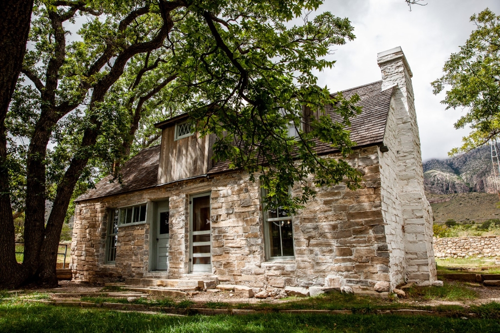
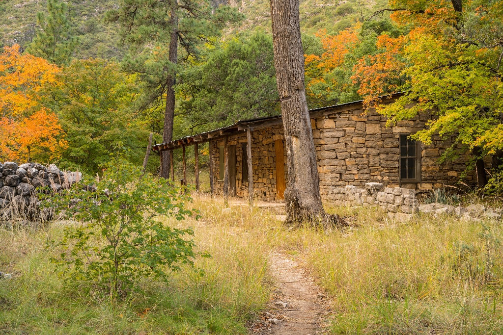
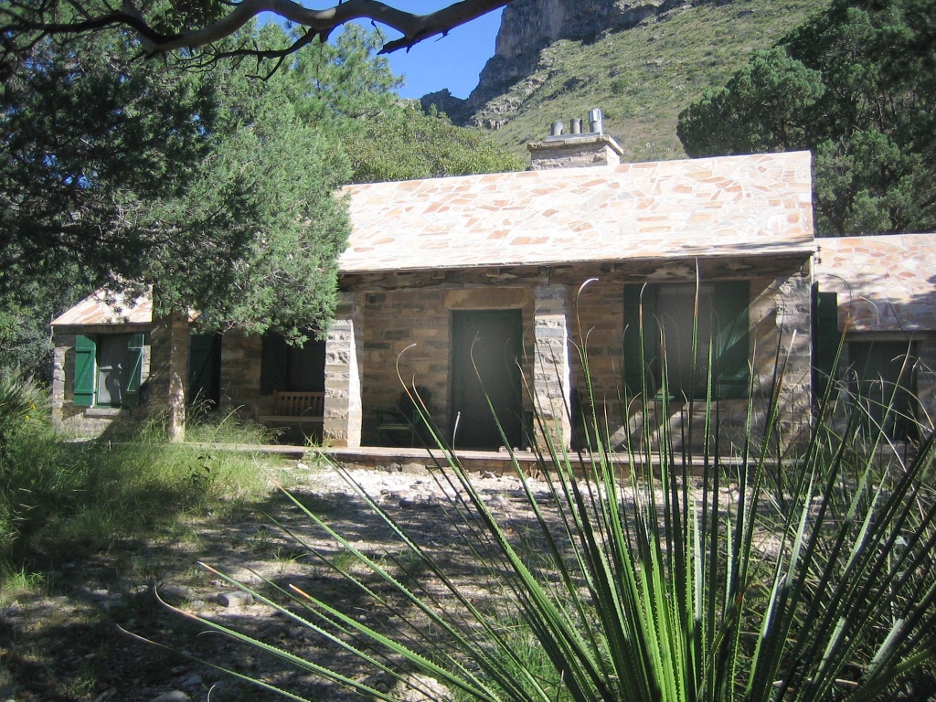
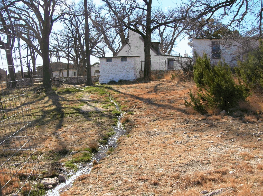
The Frijole Ranch Orchard
Orchard at Frijole Ranch, care techniques, replanted in 2006.
The orchard at Frijole Ranch was planted around 1906 by J. T. Smith. The Smiths used a variety of techniques to care for the trees, such as irrigation, fertilization with manure, planting alfalfa under the trees, and experimenting with grafting. In 2006, the orchard was partly replanted thanks to the work of a group of Eagle Scouts. The orchard was a vital part of the self-sustaining family farmstead, and the fruit trees continue to be an important part of the landscape.
The Grotto
Small cave, rock benches and tables, shady spot for picnic.
The open face of a small cave and rock benches and tables await you in the deep shade in McKittrick Canyon, a tempting location for a picnic.
The Hitching Posts
Trail ends at hitching posts, continue left on slick rock. Summit nearing!
The hitching posts below the summit of Guadalupe Peak mark the end of the portion of the trail that stock are allowed to travel. The trail continues to the left of the hitching posts on slick rock surfaces. You are nearly to the summit!
The Notch
Strenuous hike at The Notch trailhead, last day hike.
Located where the McKittrick Canyon Trail first breaks through the ridge, "The Notch" is a strenuous hike and the last traditional day hike destination within South McKittrick Canyon.
The Pinery
Visit Pinery Station ruins, experience isolation, rugged beauty, spirit of change.
Visit the ruins of the Pinery Station and get a sense of the isolation and rugged beauty that travelers experienced here in 1858. The old stone walls stand today as a testament to the spirit of change that early travelers, station keepers, and stage drivers carried as they passed this way over a century and a half ago.
Van Horn, Texas
Van Horn, Texas: gateway to Guadalupe Mountains National Park, services.
Located 55 miles to the south, the town of Van Horn, Texas is a gateway community to Guadalupe Mountains National Park. The town is located along Interstate 10 and offers a variety of basic services.
Whites City, New Mexico
Commercial development offers camping, lodging near national parks, Whites City.
Whites City, New Mexico is a commercial development offering camping and lodging and other services immediately adjacent Carlsbad Caverns National Park and thirty-five miles northeast of Guadalupe Mountains National Park.
Williams Ranch
Williams ranch house near Butterfield Overland Stage Route, Bone Spring.
A key remnant of the early Twentieth Century ranching era, the Williams ranch house lies approximately one mile northeast of the original Butterfield Overland Stage Route, which moved further south in 1859. The house is situated in a narrow valley between the Guadalupe Mountains to the east and the Patterson Hills to the west. The ranch sits at the mouth of Bone Canyon, placing it close to the perennial water source of Bone Spring.

Is there something we missed for this itinerary?

Let us know!

Itineraries across USA