The Staircase Rapids Loop is an easy 2 mile/ 3.2 km trail. It winds through old growth forest to a bridge over the North Fork Skokomish River with only a 200-foot elevation gain. A spur trail leads to a huge fallen cedar.
This trailhead also accesses the Four Stream and Shady Lane Trails, described below.
Full Accessibility Description
Four Stream Trail
Length: 1,645 feet, .31 miles
Surface Type: Compacted gravel
Typical Trail Width: 6-8 feet
Typical Running Slope: Under 5%, except the last 200 feet which has some brief steep sections up to 16%
Typical Cross Slope: Less than 2%, trail is crowned (higher in the middle than on the edges)
Elevation Gain/Loss: Less than 25 feet
Accessible Parking: Van-accessible parking along parking area.
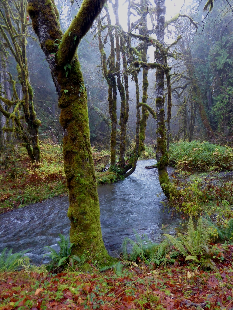
Description: The accessible portion of the Four Stream Trail runs along the southern bank of the Skokomish River, and ends at a river overlook at 1,645 feet. The trail narrows and continues beyond that point. The Staircase parking area by the ranger station has one accessible parking spot at the west end of the parking lot. Cross the bridge over the Skokomish River. The trailhead sign will be visible from the west end of the bridge. From the trailhead sign, the 8-foot-wide compacted gravel trail dips down and back up in the first 140 feet, in which 2 sections under 20 feet reach 8% grade. From here, the trail continues at grades under 5%. At 690 feet, there is an intersection with the Big Cedar Trail.
Continuing forward to the right, passing a pullout with a view of the river at 910 feet. At this point, the trail narrows to 6 feet. At 930 feet there is a 50-foot stretch at 6 to 8% grade. The trail continues at under 5% grade with another pullout at 1,150 feet before rising to another river overlook. From 1,360 to 1,390 feet the grade varies from 8-10%, increasing to a max of 16% for 25 feet. Beyond this is a gentler section with grades of 7-15% from 1,450 to 1,490 feet. After twenty feet under 6%, there is a final steep section from 7-11% from 1,510 feet to 1,525 feet. The grade is under 5% for the final approach to the overlook which is at 1,645 feet.
Shady Lane
Length: 4,410 feet, .84 miles (trailhead at end of bridge to Four Stream Road trailhead)
Surface Type: Compacted gravel
Typical Trail Width: 2 feet
Typical Running Slope: First quarter of trail is rugged with numerous very steep sections 20-40% grade. From 1,050 to 3,940 feet mainly under 6% grade with occasional steep section 12-17%. Final 500 feet starts with an 85-foot section at 30-35% grade and is then mostly under 6% grade with a few 10-foot sections at 15% grade
Typical Cross Slope: Less than 2%, trail is crowned (higher in the middle than on the edges)
Accessible Parking: Van-accessible parking along parking area
Description: From the Staircase parking area, across the bridge over the Skokomish River, the trailhead is identified by a sign on the left-hand side at the far end of the bridge. The next 310 feet of the trail is compacted gravel 3 feet wide. The first 20 feet of this stretch of trail descends from the bridge at a steep 16% grade, decreasing to 8% to 50 feet, and then leveling out to less than 5% grade to 310 feet. The tread then becomes quite rocky to 430 feet, with cross slopes up to 4%.
At 425 feet, there is a steep informal trail down to the river’s edge. At 430 feet, 2 steps lead up to a 2-foot wide, 40-foot-long bridge. The trail width remains at 2 feet for the remainder of the trail. From the end of the bridge to 1,050 feet, the trail follows the contours of the river along a steep slope that has been impacted by several slides. There is a short spur trail to an old mine shaft on the far side of the bridge.
The trail continues to the left, proceeding downhill at grades up to 10% to 500 feet. A water bar runs across the trail at 515 feet before the trail begins uphill to cross the slide area. From 555 feet to 570 feet, there is a rugged stone staircase with 6 steps. The trail continues downhill again at grades up to 18% to a 25-foot level section that is held in place by a large log. Beyond the log, the trail climbs uphill at 10% and then steepens to 20% grades with 2 stone steps in the middle from 675 feet to 695 feet before again going downhill at 14-20% to 765 feet. Going uphill again at 10% from 765 to 790 feet, the trail reaches a second bridge, 25-feet long. Beyond the bridge, the trail runs downhill with sections of exposure to a 15-foot drop on the river side, before dropping steeply through a section of bedrock from 830 to 855 feet.
The next section continues downhill at 20% grade with many roots in the trail from 875 feet to 900 feet. From 900 to 935 feet, the climb increases to 40% grade before becoming more gradual to 985 feet and switching again to downhill at 20% grade to 1,050 feet. From this point on, the trail enters the forest. There continue to be steep sections and periodic roots and rocks in the trail, but they are interspersed with long gentle sections under 6% grade that weave between impressive old-growth cedar trees.
From 1,050 to 1,830 feet, the trail meanders through the woods at grades under 6%. At 1,830 feet, there is a 15-foot downhill at 17% followed by a brief uphill around a large fallen tree. At this point, the trail fluctuates downhill at up to 17% grade to 1,975 feet, followed by gentler downhill under 7% grade to 2,220 feet. From 2,220 to 2,535 feet, alternating gentle ups and downs in the trail under 6% lead to a root-heavy downhill at 14% for 25 feet. Beginning uphill again, gentle grades run to 2,695 feet at 9% before beginning downhill again. The next stretch of trail covers grades under 6% to 3,710 feet, and one 12% from 2,775 to 2,815 feet.
There is an intersection with an unofficial trail to the river at 3,710 feet. This is a good point to turn around, if returning to the Staircase parking area, as the remainder of the trail is a climb up to the Four Stream Road trailhead. If continuing, proceed to the right from the intersection. From 3,940 to 4,025 feet there is a very steep 30-35% climb. The remainder of the hike is uphill at gentle grades, interspersed with a few 10-foot sections at 15%. Arrive at Four Stream Road at 4,410 feet.
Is there something we missed for this itinerary?
Itineraries across USA


