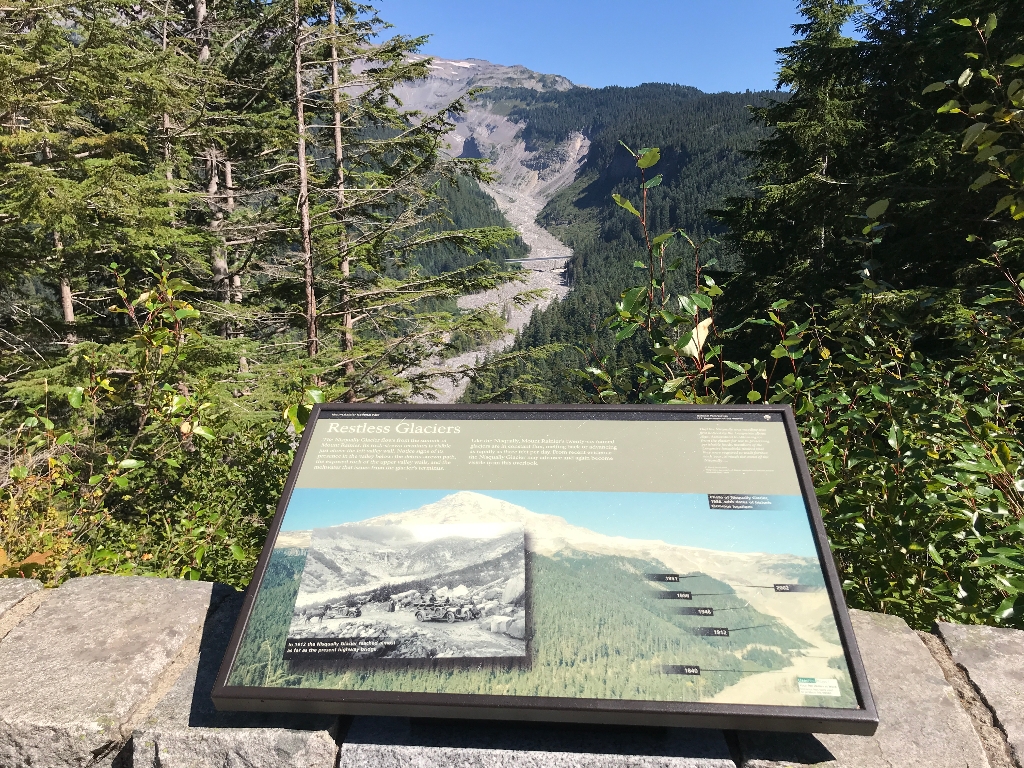
Title: Restless Glaciers
Main Text
The Nisqually Glacier flows from the summit of Mount Rainier. Its rock-strewn teminus is visble just above the left valley wall. Notice signs of its presence in the valley below: the debris-strewn path, the exposed rock of the upper vally walls, and the meltwater that issues from the glacier's terminus.
Like the Nisqually, Mount Rainier's twenty-six named glaciers are in constant flux, melting back or advancing as rapidly as three feet per day. From recent evidence the Nisqually Glacier may advance and again become visible from this overlook.
Secondary Text
"That the Nisqually was receding was first noticed by the Longmires about 1890. Accustomed to obtaining ice from the glacier for use in preserving perishable foods, members of the Longmire household noticed that they were required to walk farther, each year, to reach the snout of the Nisqually...."
- C. Frank Brockman, Progressive summary of Glacier Recession in Mount Rainier National Park, 1940
Exhibit Panel Description
The main text stretches across the top third of the exhibit panel, with the secondary text quote on the right, against a tan background. Below the text, a large photo of a mountain fills the remaining two thirds of the exhibit panel. In the upper right corner of the photo a caption reads: "Photo of the Nisqually Glacier, 1956, with dates of historic terminus locations." On the right side of the photo, a deep river valley descends from a glaciated summit of the mountain down through forested lower slopes. Along the rocky riverbed, black lines mark out locations labeled with years. The first year, 1840, is furthest downstream, below a tall bridge that stretches across the river bed. Above the bridge, a location along the river is labeled 1912. Moving upstream, the next location is 1946, then 1956, then 2002, and then finally 1951 is marked where the valley curves out of view behind a forested outcrop on the slope of the mountain. Overlaying the main photo on the left, a historic black and white photo shows a dirt road crossing the river bed. A rock-covered terminus of a glacier is just upstream of the road. Several people stand along the road next to early-model cars and a horse-drawn wagon viewing the glacier terminus. A caption in the lower left corner of the photo reads: "In 1912 the Nisqually Glacier reached almost as far as the present highway bridge." A small box in the lower right corner of the exhibit panel reads "User Fee Project. Your Fee Dollars at Work. Entrance fees were used to produce this exhibit".
Visit This Exhibit Panel
Ricksecker Point is located approximately 6.5 miles from Longmire and 5 miles from Paradise along the road to Paradise. A one-way scenic loop drive traces the edge of Ricksecker Point. The first exhibit panel is located in the first pullout along the road, overlooking the Nisqually River Valley and Glacier Bridge. Ricksecker Point Road is open to vehicles during the summer, typically from May-October.
Is there something we missed for this itinerary?
Itineraries across USA


