Season: Summer Only (May - October)
Ohanapecosh is open to vehicles via SR123 during the summer only, typically from May to early November. Hikers, snowshoers, and snowmobiles can use the closed road during the winter.
Ohanapecosh is located on the southeast side of the park, a few miles beyond the park boundary on SR123. It is just minutes from the Stevens Canyon Entrance, which provides access to Paradise, and it is 13 miles from SR410, which connects to the White River, Sunrise, and Tipsoo Lake areas, as well as the towns of Enumclaw and Yakima, WA. The area is home to the Ohanapecosh Visitor Center and campground. The Ohanapecosh Campground has 188 sites for RV or tent camping. Each site has a bear box for campers to secure food, as well as a designated fire ring. There is a bathroom in each campground loop. There are no electrical hookups at the Ohanapecosh Campground.
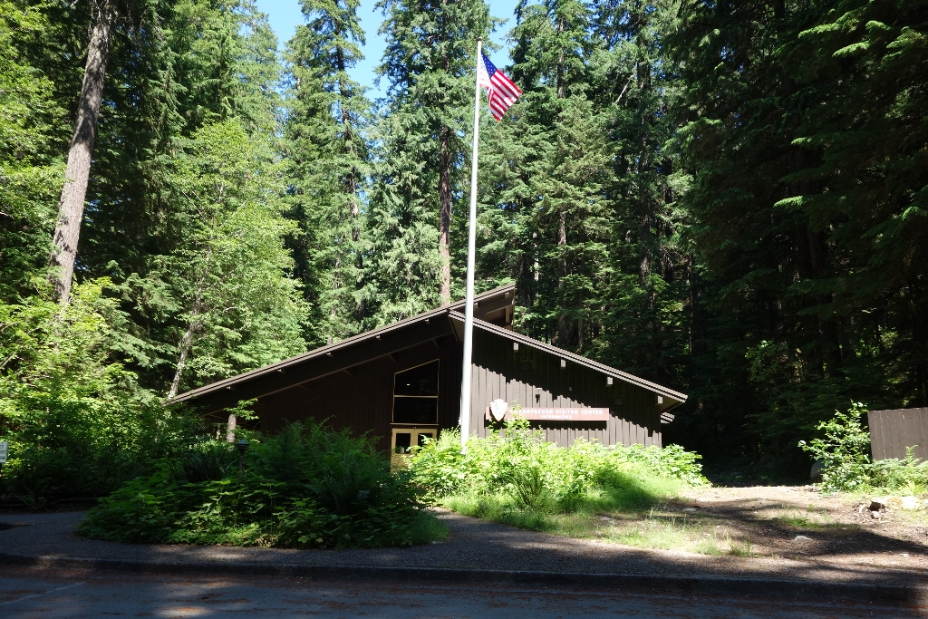
The Ohanapecosh Visitor Center is a large building with a pitched roof, designed in the classic Mission 66 style. Upon approaching the building, there is a double doored entrance and to the left a covered outdoor hallway leads to restrooms, a pay phone, and a water fountain.
Ohanapecosh has a long history of human use. The area is still used by members of the Cowlitz and Yakama tribes. Due to sampling done in the Ohanapecosh Campground in 2014, archaeologists were able to find the first ever, low elevation, pre-contact sites within the park. More field work followed in the summer of 2015, yielding artifacts like chipped stone tool remains and hearth features dating to between 3,700 and 6,400 years ago. It is believed that Ohanapecosh served as a way-stop to and from high elevation summer sites used for hunting and resource-gathering. Please remember that all historic and archaeological artifacts you might find must be left in place. This allows archaeologists to learn much more about our cherished history. Report anything you notice to the nearest visitor center or park ranger.
Volcanic hot springs still bubble near the campground. These hot springs were developed into a Hot Springs Resort in the early 1900s, but the resort fell into disrepair in the 1950s and was closed in 1960. The National Park Service had several stages of development, from the construction of the campground and trails by the Civilian Conservation Corps in the 1930s, to the development of the visitor center and employee housing during the Mission 66 era in the 1950s-60s. The hot spring area was also restored to a more natural state and the resort buildings were removed.
Hiking
Tucked amongst low-elevation forest next to the Ohanapecosh River, hiking access abounds. Most hikes are family friendly and short in length, including the popular Silver Falls Trail. The Silver Falls Trail connects to the Eastside Trail, with access to the Grove of the Patriarchs. The hot springs can be viewed along the Hot Springs Nature Trail, which starts behind the visitor center.
NOTE: The Grove of the Patriarchs is CLOSED to all public entry due to flooding in November 2021 which caused significant damage to the suspension bridge that provides the only safe access to the area (News Release, 11/17/21). The Grove of the Patriarchs Trail will remain closed until the bridge can be replaced, which will first require a series of environmental evaluations and engineering work to reevaluate the bridge design. During the closure, the Grove of the Patriarchs parking lot and restrooms have normal seasonal access, along with the Eastside and Silver Falls Trails. Construction to replace the bridge is scheduled to begin summer 2027. Summers represent the only viable construction season in the park due to the heavy snow that blankets the park from roughly November through May.
Is there something we missed for this itinerary?
Itineraries across USA


