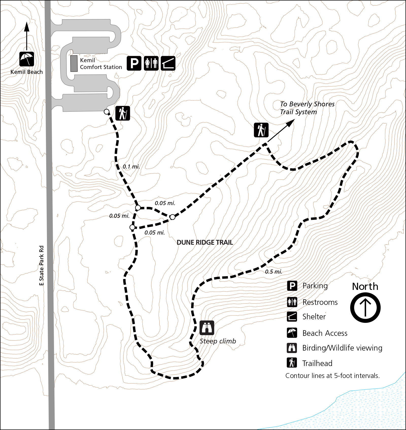
Dune Ridge Trail
0.7 miles, 73 feet of elevation gain, 4% average grade, 11% maximum gradeHike time: 30 minutes
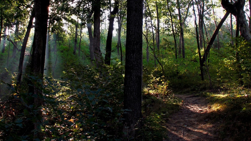
The Dune Ridge Trail offers great views of the extensive wetlands and forests south of this tall, forested dune. The different habitats you'll see along the trail help make Indiana Dunes National Park one of the top most biologically diverse of all the national parks.
The featured hike is a lollipop shaped trail. From the parking lot trailhead, head south with a short tour through a foredune complex on sandy soil. It transitions into an oak savanna with a more stable soil structure, which provides better footing. At the junction with the loop trail, turn left to hike the loop in the clockwise direction. The loop starts on an old roadbed and you will need to turn right to leave the wide road onto single track. The trail will climb to the top of the dune offering sweeping views of the Great Marsh. Follow the trail along the ridge line before hiking down a steep section of loose sand. The trail will wind back to the loop junction. At the junction, turn left and follow the trail north to the parking lot.
Trail Features: Overlook, Birding, Fall Colors, Wildflowers and Wildlife
Must See Gems: Great Marsh Overlook, Kemil Beach
History and Background
Perhaps no other area in Indiana Dunes National Park will take you through as many diverse habitats in a short trail. Begin your habitat adventure by following the trail located in the southeast corner of the parking lot through the foredune habitat. Foredunes contain many pioneer plants such as marram and little bluestem grasses and cottonwood trees. These plants are specially adapted to live in the dunes where moving sand sometimes partially buries or uncovers plant stems and roots. Although those grasses may seem hearty, they may die when stepped upon. Able to withstand battering by sand and wind, grasses will eventually succumb to the shade of taller plants providing the necessary soil for the oak forest that lies ahead.Getting There
Dune Ridge Trailhead and Kemil Beach Parking Lot
North of U.S. Highway 12 on East State Park Road (300E), Beverly Shores, IN 46301.
Note: East State Park Road is called Kemil Road to the south of U.S. Highway 12.
Trailhead GPS Coordinates
41.677357, -87.008950 (Decimal Degrees)
Need to Know
Hours & Information- Hours – Open daily from 6:00 am to 11:00 pm.
- Trail Length – 0.7 miles. 73 feet of elevation gain, 11% maximum grade.
- Hike Time – 30 minutes to 1 hour.
- Difficulty – Moderate with some steep slopes in loose sand.
- Trail Surface – Mixture of loose sand and packed dirt.
- Facilities – Year-round restrooms and potable water.
- Pets – Permitted on a leash (6' or shorter).
- Prohibited – Bicycles and motorized vehicles.
- Prohibited – Littering, hunting, and removing plants.
- Parking lot is paved and will fill up quickly on summer weekends.
- Visit the Kemil Beach page for information on swimming and other beach activities.
- Please stay on the trail and respect closed area signs. Going off trail damages fragile habitat.
- Ticks are present year-round. Take precautionary measures to prevent bites.
- Poison ivy can be present on the edges of the trail.
- Be prepared for changing weather conditions.
- In case of an emergency or to report a crime, call 1-800-PARK-TIP.
- Trails are not wheelchair accessible. Restrooms are accessible.
Trail Map
All hiking trail maps of the Indiana Dunes National Park are available online on our website or in paper at the trailhead kiosk or the Indiana Dunes Visitor Center.
Nearby Hikes
Great MarshMount Baldy
Glenwood Dunes
Is there something we missed for this itinerary?
Itineraries across USA

Acadia

Arches National Park

Badlands

Big Bend

Biscayne

Black Canyon Of The Gunnison

Bryce Canyon

Canyonlands

Capitol Reef

Carlsbad Caverns

Channel Islands

Congaree

Crater Lake

Cuyahoga Valley

Death Valley

Dry Tortugas

Everglades

Gateway Arch

Glacier

Grand Canyon

Grand Teton

Great Basin

Great Smoky Mountains

Guadalupe Mountains

Haleakalā

Hawaiʻi Volcanoes

Hot Springs

Indiana Dunes

Isle Royale

Joshua Tree

Kenai Fjords

Kobuk Valley

Lassen Volcanic

Mammoth Cave

Mesa Verde

Mount Rainier

North Cascades

Olympic

Petrified Forest

Pinnacles

Rocky Mountain

Saguaro

Shenandoah

Theodore Roosevelt

Virgin Islands

Voyageurs

White Sands

Wind Cave

Yellowstone

Yosemite

Zion