tsʰaquɬqla is the Chumash word for Scorpion Rock. The meaning is unknown.
Please see "Ethnographic Island Place Names" below for more information on island place names.
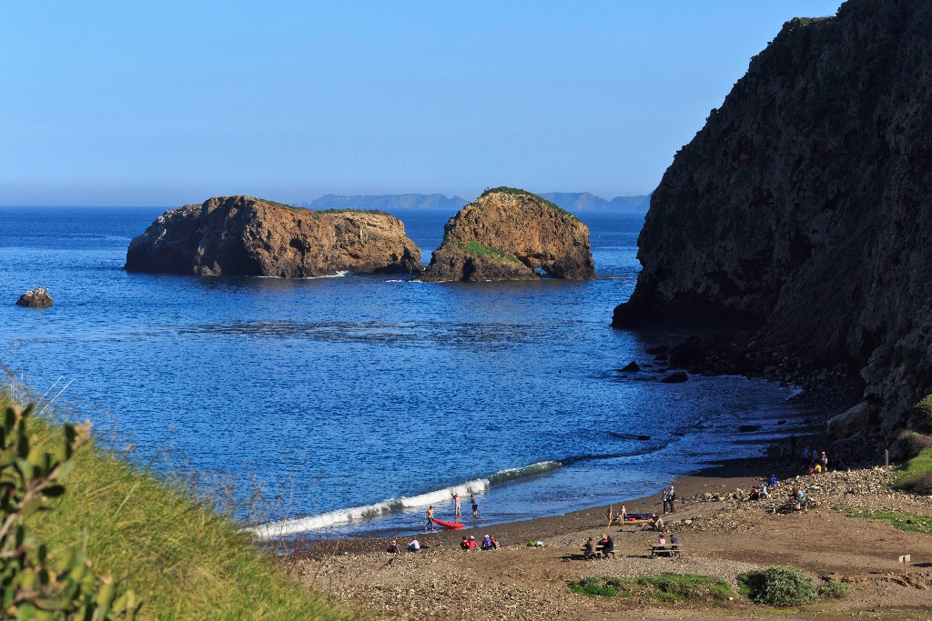
Scorpion Rock is closed to all landing to protect nesting and roosting seabirds.
An Ideal Isolated Home
A cool, salty mist fills the air as you approach Scorpion Rock overlook. The ever-present western gulls and graceful pelicans often can be sighted soaring along the steep, rugged volcanic cliffs. These cliffs, their numerous caves, and the rest of Santa Cruz Island's coastline and neighboring islets are home to eleven different species of nesting seabirds and shorebirds, including ashy storm-petrels, Brandt's cormorants, Cassin's auklets, pigeon guillemots, and black oystercatchers.
Santa Cruz Island, the other Channel Islands, and all their associated islets and offshore rocks are vital habitat for seabirds and shorebirds, providing essential nesting and feeding grounds for 99% of seabirds in southern California and important wintering areas and stopover points for shorebirds. Their isolation and freedom from predators and human disturbance, and the abundance of food in the cold, nutrient-rich ocean waters, make them an ideal place for marine birds to breed and rear their young.
Thirty shorebird and twelve seabird species have been recorded, including: half of the world's population of ashy storm-petrels and western gulls; 80% of the U.S. breeding population of Scripps's murrelets; the only major breeding population of California brown pelicans in the western U.S.; and the the largest colonies in southern California of Cassin's auklet, western gulls, Scripps's murrelets, rhinoceros auklets, tufted puf fins, ashy storm-petrels, double-crested cormorants, pigeon guillemots, and black storm-petrels.
Impacts to Seabirds
Seabirds in the park and throughout southern California are impacted by many factors including contaminants, oil spills, invasive species, and changes in the ocean environment. For example, the introduction of DDT, a long-lived pesticide, into the marine environment has severely impacted seabird populations at the islands. Before DDT was banned in the 1970s, California's brown pelican population suffered nearly complete reproductive failure.
On land, predation and habitat disturbance by invasive species have impacted seabirds. At Anacapa, introduced black rats preyed heavily on seabird eggs and chicks severely depleting populations of Scripps's murrelets. Black rats still prey on seabird populations on San Miguel. At Santa Barbara Island, seabirds were decimated by cats and habitat has been marginalized by years of over grazing by introduced livestock and rabbits. Seabird habitat has also been severely impacted by grazing of non-native animals on Santa Cruz Island. On Scorpion Rock, but human disturbance caused the entire colony to be abandoned by the 1930s.
Seabird Monitoring and Restoration
Today, the gradual recovery of these species continues as their isolated island home is ensured protection within Channel Islands National Park. Through monitoring and restoration programs, the park and its partners are working to conserve critical nesting habitat and to protect the integrity of island and marine ecosystems that support 90 percent of the seabird populations in southern California.
On Santa Cruz Island, these efforts have focused on closing off public access to certain habitat critical sea caves and restoring seabird habitat on Scorpion and Orizaba Rocks. These rocks are important nesting islets for burrow-nesting seabirds. To restore seabird habitat on these islets, restoration efforts have included removing non-native vegetation, revegetation with native plants, installation of nest boxes, and closures to protect nesting seabirds. For more information about seabird restoration visit Seabird Restoration Videos and Montrose Settlement Restoration Program .
Ocean Habitat
Mixing of Waters and the Diversity of Marine Life
The Channel Islands lie within a large embayment known as the Southern California Bight-an area just below Point Conception where the California coastline turns sharply to the east. Within this area, the sea floor is comprised of canyons, banks, escarpments, sea mounts, and deep basins (the Santa Cruz Basin off the island's south coast is deeper than the Grand Canyon). Nutrient-rich waters upwelling from these depths mix and mingle with cool waters from the north (California Current) and warm southern waters (California Countercurrent), creating the Santa Barbara Gyre-a swirling eddy that circulates nutrients and supports a wealth of marine plants and animals, from giant kelp forests and blue whales to tiny crabs and plankton. Here, northern and southern species overlap, creating a transition zone between the Oregonian and Californian marine biogeographic provinces. Santa Cruz Island lies in the middle of this transition zone. The western half of the island harbors numerous northern species, while southern species are more common on this eastern end of the island.
Santa Cruz Island also serves as the meeting ground for seabirds and shore birds that rarely occur together, such as black oystercatchers from the north and American oystercatchers from the south. Both species, as well as hybrids between the two, have nested at Fraser Point on the island's west end. Other northern birds, such as pelagic cormorants and pigeon guillemots, overlap with additional southern species, such as Scripps's murrelets and California brown pelicans.
The Giant Kelp Forest
From this vantage point, one also has the opportunity to gaze upon another part of the park-the marine environment. One nautical mile of water around each island in the park is part of Channel Islands National Park (six nautical miles around each island is part of Channel Islands National Marine Sanctuary).
Within this ocean realm below one may be able to see or hear California sea lions. These playful animals are often spotted just to the west of Potato Harbor, hauled-out on the rocks. Sea lions, along with a variety of other marine species, depend upon the extensive kelp forests that can be found around Santa Cruz Island and the other Channel Islands. While urban and industrial development has altered much of the southern California coastal mainland, the islands contain the most undisturbed stretches of coastline in this region, providing some of the best conditions for kelp forests and their inhabitants.
Kelp is a type of algae that, under ideal conditions (cold, nutrient-rich water), is one of the fastest growing plants on earth-it can grow 2 feet per day. This foliage provides food, shelter, and protection for over 800 different species-from foraging nudibranchs, to grazing snails, to fish seeking refuge, to whales seeking a plankton snack.
But we must not forget about ourselves. Not only do we feed upon some of the animals that depend upon the kelp forest, but those of us who eat ice cream, salad dressing, and even use tooth-paste are also using a little bit of kelp as well. Kelp is harvested for a natural ingredientcalled algin, which is used as a suspending, stabilizing, emulsifying, gel-producing, and film-forming additive in more than 70 commercial products. In addition, marine plants such as kelp provide the earth with 80 percent of its oxygen.
Despite these benefits, the kelp forest and its inhabitants are in jeopardy. Pollution and over-harvesting of marine species have completely altered the kelp forest ecosystem. Kelp forests in southern California today cover less than half the area they covered at the turn of the century.
Marine Protected Areas
However, with the establishment of Marine Protected Areas (MPAs), improved pollution controls and fishing regulations, transplantation of kelp, public education, and various research programs some of these problems have been corrected.
Within the park and sanctuary a network of MPAs provide a refuge for sea life and opportunities for recreation, education, and science. In 11 Marine Reserves (including the Scorpion Marine Reserve in the waters below you from Potato Harbor to Scorpion Rock), recreational fishing and commerci;al harvest are prohibited; limited fishing and harvest are allowed in two Marine Conservation Areas. The MPAs total 318 square miles, the largest such network off the continental United States and part of a larger effort throughout the world to conserve natural, historic, and cultural marine resources.
Ethnographic Island Place Names
Ethnographic island place names aid in native language revitalization, illustrate cultural values, and provide tangible connections to cultural landscapes and seascapes.
Many of these place names were recorded by ethnographers and anthropologists in the late 1800 and early 1900s. J.P. Harrington was an ethnographer who worked for the Smithsonian Institution in Washington, D.C., from 1915 to 1955. He interviewed American Indian consultants, including Chumash and Gabrielino Tribal members, and recorded information about native languages and culture.
Chumash Indians Fernando Librado (Kitsepawit) and Juan Estevan Pico were the main sources for island place names. They were both born and raised in Ventura. They learned of the island places from Chumash elders, most notably Ursula (of wima) and Martina (of limuw.) Pico's interviews of Martina resulted in a list of island place names given in order from east to west (or vice/versa,) to anthropologist, H.W. Henshaw. Anthropologists have cross-referenced Pico's list with the archeological record, baptismals, and marriage patterns.
Twenty-six new place names were recently identified and mapped by Mark Vestuto (Barbareño/Ventureño Band of Mission Indians; Advocates for Indigenous California Language Survival) with assistance from Kristin Hoppa (Archeologist, Channel Islands National Park) and the Chumash community. These names reference island peaks, water, landforms, islets, trails, caves, and beaches.
Please note that lowercase is used because capitalization is a convention in English which poses problems in the writing of native languages.
Is there something we missed for this itinerary?
Itineraries across USA


