pasʰyǝmu pʰmihi̇ swaxǝɬ is the Chumash word for Scorpion Canyon and creek. It means 'the trail of fresh water at swaxǝɬ.'
Please see "Ethnographic Island Place Names" below for more information on island place names.
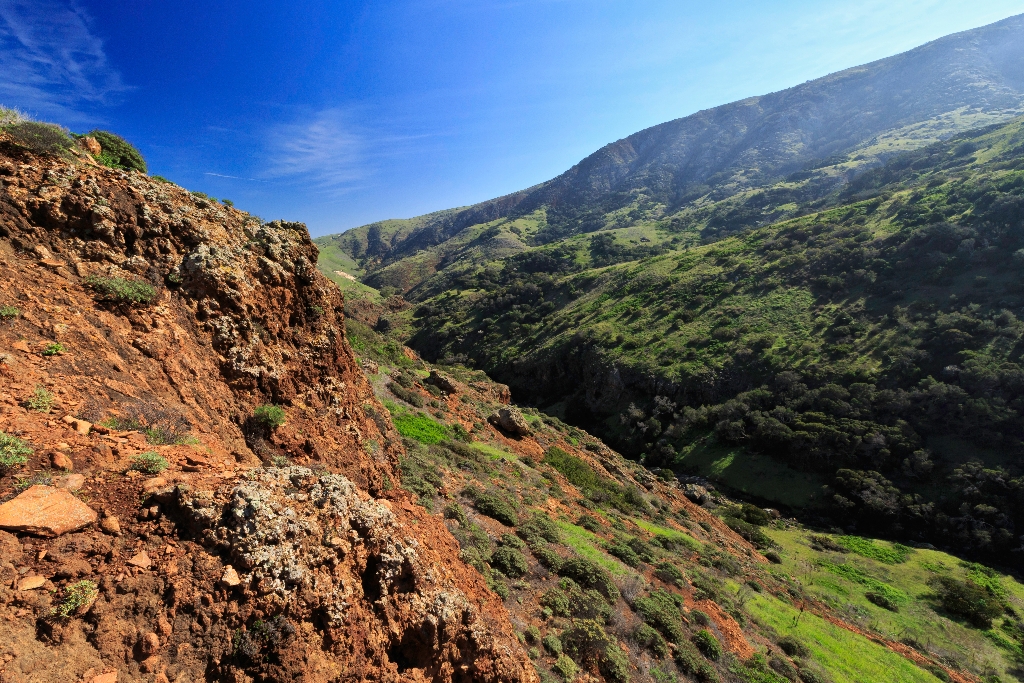
Geology of Scorpion Canyon
Above the canyon lies a layer of the Monterey Formation, a siliceous shale. Within the canyon, erosion has exposed the volcanic rocks lying underneath. These rocks reveal a fascinating story about the formation of the Channel Islands. Between 15-30 million years ago, lava flows and volcanoes covered much of the area that now comprises the northern Channel Islands and the western Santa Monica Mountains. In some places the lava accumulated to as much as 10,000 feet thick. A certain type of lava, pillow lava, found in some of these rocks is evidence that much of the volcanic action took place below the surface of the ocean. In other places, oyster shells and other marine fossils are found embedded in the lava. At times, the buildup of lava was great enough that volcanic islands formed. These islands probably were short lived and were eroded to below sea level after the volcanic action ceased.
The reason for these volcanic eruptions can be found within the magnetic particles in the rocks. As the rocks were cooling, magnetic particles within the rocks would have been set in line with the magnetic poles of the earth. However, magnetic measurements now taken in these same rocks show that they do not line up. In fact, they are off by about 100 degrees, with the oldest rocks showing the largest discrepancy. Geologists believe that when these rocks were formed, the platform on which the islands rest lined up in a north-south direction along the southern coast of California, with San Miguel Island's position lying just offshore from San Diego.
As the Pacific plate made contact with and began to slide past the North American plate, forming the San Andreas fault, this platform was rotated in a clockwise direction to its present east-west position. As it rotated, the crust of the ocean thinned and the resulting reduction of pressure allowed molten magma to form and ascend from the mantle, erupting under the sea as lava.
Around 5 million years ago, compressional forces, caused by the ramming of Baja California into southern California, resulted in folding and faulting of these marine sediments and volcanic rocks (deposited between 15-30 million years ago) and the eventual uplift of the islands. These compressional forces are still ongoing, making this area geologically active today. Earthquakes are quite common. A major fault that runs through the center of the island has moved nearly 100 feet in the last 30,000 years, and all the islands continue to be uplifted.
Ever since these compressional forces caused the islands to emerge from the sea, they have been separated from the mainland. For decades, scientists assumed that the two were connected by a landbridge, but as bathymetric information (or topography) of the sea floor improved, it revealed that even during periods of lowest sea levels (about 17,000 years ago), the islands still remained isolated by at least four miles of ocean. It is this continuous geographical isolation that has shaped island life.
Ethnographic Island Place Names
Ethnographic island place names aid in native language revitalization, illustrate cultural values, and provide tangible connections to cultural landscapes and seascapes.
Many of these place names were recorded by ethnographers and anthropologists in the late 1800 and early 1900s. J.P. Harrington was an ethnographer who worked for the Smithsonian Institution in Washington, D.C., from 1915 to 1955. He interviewed American Indian consultants, including Chumash and Gabrielino Tribal members, and recorded information about native languages and culture.
Chumash Indians Fernando Librado (Kitsepawit) and Juan Estevan Pico were the main sources for island place names. They were both born and raised in Ventura. They learned of the island places from Chumash elders, most notably Ursula (of wima) and Martina (of limuw.) Pico's interviews of Martina resulted in a list of island place names given in order from east to west (or vice/versa,) to anthropologist, H.W. Henshaw. Anthropologists have cross-referenced Pico's list with the archeological record, baptismals, and marriage patterns.
Twenty-six new place names were recently identified and mapped by Mark Vestuto (Barbareño/Ventureño Band of Mission Indians; Advocates for Indigenous California Language Survival) with assistance from Kristin Hoppa (Archeologist, Channel Islands National Park) and the Chumash community. These names reference island peaks, water, landforms, islets, trails, caves, and beaches.
Please note that lowercase is used because capitalization is a convention in English which poses problems in the writing of native languages.
Is there something we missed for this itinerary?
Itineraries across USA


