Ponderosa Canyon is so named because of the huge Ponderosa Pines on the canyon floor. Some of these trees measure more than 5 ft. in diameter and exceed heights of 150 ft. However from high above at the viewpoint you would never know this. In fact many are confused by the name, not expecting to find themselves surrounded by a forest of Engelmann spruce and Douglas-fir. Certain types of vegetation grow in certain environments according to conditions such as moisture and temperature. These conditions are strongly controlled by elevation. Forests, therefore, are divided into zones or forest types according to elevation, because a forest's dominant tree species varies with these changes in elevation.
Bryce Canyon National Park encompasses three of these forest types from the lowest elevations below the rim of the canyon to the upper elevations in the southernmost end of the park. At the bottom is the Pinyon-Juniper Woodland Belt, dominated by the Pinyon Pine and the Utah Juniper. The rim of the canyon in the northern end of the park is dominated by the Ponderosa Pine, and is thus classified as the Ponderosa Pine Forest. At the highest elevations, like here at Ponderosa Point, Engelmann Spruce, Douglas-fir and White Fir are the most common tree species, indicative of a Mixed Conifer Forest.
Trails
Trail Closed due to Rockfall
From here, the Agua Connector Trail descends 1.6 miles (4.0 km) to its junction with the Under the Rim Trail approximately 1,000 feet (305 m) below.
Landscape Features
To the South
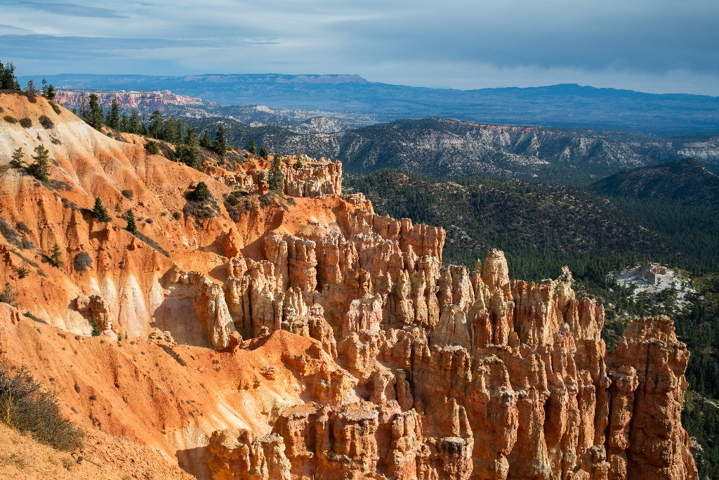
See the hoodoos eroded from the edge of the Paunsaugunt plateau contained within a bowl-shaped amphitheater shared with Rainbow Point. A forest floor of pine and fir lies 1,000 feet (305 m) below.
To the Southeast
Navajo Mountain looms on the distant horizon over 80 miles (129 km) away near Page, Arizona. Called a laccolith, Navajo Mountain can be thought of as a volcano that never quite happened. As the Colorado Plateau was uplifted over the last 20 million years, a plume of molten rock moved upward from deep inside the Earth causing a swelling much like a large blister. Unlike a volcano, Navajo Mountain never blew its top and so the plume cooled slowly, creating the hard core of the mountain that still exists today.
To the East
The Paria Valley and the upper steps of the Grand Staircase exposed within it present most of the view. Across the valley, the Table Cliff plateau stands at 10,000 feet (3048 m) and is composed of the same Claron formation (or "Pink Cliffs") as Bryce Canyon's hoodoos. This difference in elevation is due to the presence of the Paunsaugunt fault--a major normal fault that runs northeast to southwest along the park's eastern boundary. Uplift of the Colorado Plateau over the last 20 million years is responsible for the nearly 2,000 feet (607 m) of elevation difference expressed by this fault. Below these Pink Cliffs, observe the shale-rich badlands of the Grey Cliffs slowly transform to the sometimes iron-rich sandstones of the upper White Cliffs. Kodachrome State Park is located in this transition zone.
Almost the same distance to Navajo Mountain in the southeast, the Henry Mountains can be seen on days with good air quality, 86 miles (138 km) away beyond the eastern horizon. Like Navajo Mountain, these too are laccoliths--or plumes of molten rock that warped the rocks above them, but never broke through as a volcano would. As with the terrain of Capitol Reef National Park, which lies just in front of these peaks, millions of years of erosion have now occurred, and at the Henry Mountains it has removed the overlying rock and exposed the hard igneous cores within these mountains.
To the North
Observe the eroded edge of the Paunsaugunt Plateau, punctuated by bowl-shaped amphitheaters.
To the West
The rolling ponderosa forest of the Paunsaugunt plateau is deeply incised here by water travelling north to the Tropic Reservoir. The direction of flow is decided by the plateau's upward tilt to the south and has created a rain divide between the Great Basin of Nevada and the Colorado River that follows the edge of this plateau.
Backcountry Hiking and Camping
The Under-the-Rim Trail is approximately 22.9 miles (36.9 km) from Bryce Point to Rainbow Point. Connecting trails offer access from the park's Scenic Drive and intersect the Under-the-Rim Trail at Swamp Canyon, and Whiteman Bench. Agua Canyon Connector Trail **is closed** until further notice due to storm damage.
The Riggs Spring Loop is an 8.6 mile (13.9 km) hike beginning and ending at the Rainbow and Yovimpa Point parking lot at the south end of the Scenic Drive. Either the Yovimpa or Rainbow Point trailhead may be used to access this loop.
A backcountry hiking map with mileage is available at the Visitor Center. More information
Permits Required
A Backcountry Permit is required for all overnight stays in the backcountry. Permits may be purchased at the Visitor Center from 9 am - 12:30 pm and 1:30 pm to 6 pm. Backcountry campsites are limited to 6 people per regular site, and 15 people per group site.
No Fires Permitted
Though gas-powered cooking stoves are allowed, no open fires are allowed anywhere in the park outside of North and Sunset Campground's established fire rings.
Bears and Other Wildlife
Bryce Canyon is home to many animals including mountain lions, coyotes and black bears. Squirrels, snakes and other small animals may also be present near your campsite.
Due to the presence of black bears within Bryce Canyon National Park, the use of bear-resistant food canisters on overnight backcountry hikes is highly recommended. Bear-resistant canisters are available for loan, free of charge, at the Visitor Center.
Transportation
No park-provided transportation is provided south of Bryce Point. You can arrange a private shuttle using approved providers listed on our Commercial Tours and Services page.
Is there something we missed for this itinerary?
Itineraries across USA


