At Agua Canyon two prominent hoodoos command attention. On the left, is the taller of the two towers, "The Hunter." To the right is a hoodoo commonly referred to as the "Rabbit" or alternatively the "Backpacker." In the early years of Bryce Canyon National Park a great effort was made to name many of the more prominent hoodoos. Over the years many of these have fallen or partially fallen so that they look nothing like the things they were originally named for. As a result hoodoos are no longer being named and many of the more obscure names are being dropped from newer publications. The good news is that you, the park visitor, now have the liberty to exercise your own creativity. Is the rabbit a backpacker or maybe even a thumb? It's up to you to decide. Let your imagination run!
Trails
No trails depart from this area. The Agua Connecting Trail (currently closed due to rockslide) is found at Ponderosa Canyon, the next overlook to the north.
Landscape Features
To the Southeast
Navajo Mountain still looms on the distant horizon over 80 miles (129 km) away near Page, Arizona. Called a laccolith, Navajo Mountain can be thought of as a volcano that never quite happened. As the Colorado Plateau was uplifted over the last 20 million years, a plume of molten rock moved upward from deep inside the Earth causing a swelling much like a large blister. Unlike a volcano, Navajo Mountain never blew its top and so the plume cooled slowly, creating the hard core of the mountain that still exists today. By following the eastern horizon you may be able to see the southern tip of the Kaiparowits plateau, which is separated from Navajo Mountain by the Colorado River within Glen Canyon National Recreation Area.
To the East
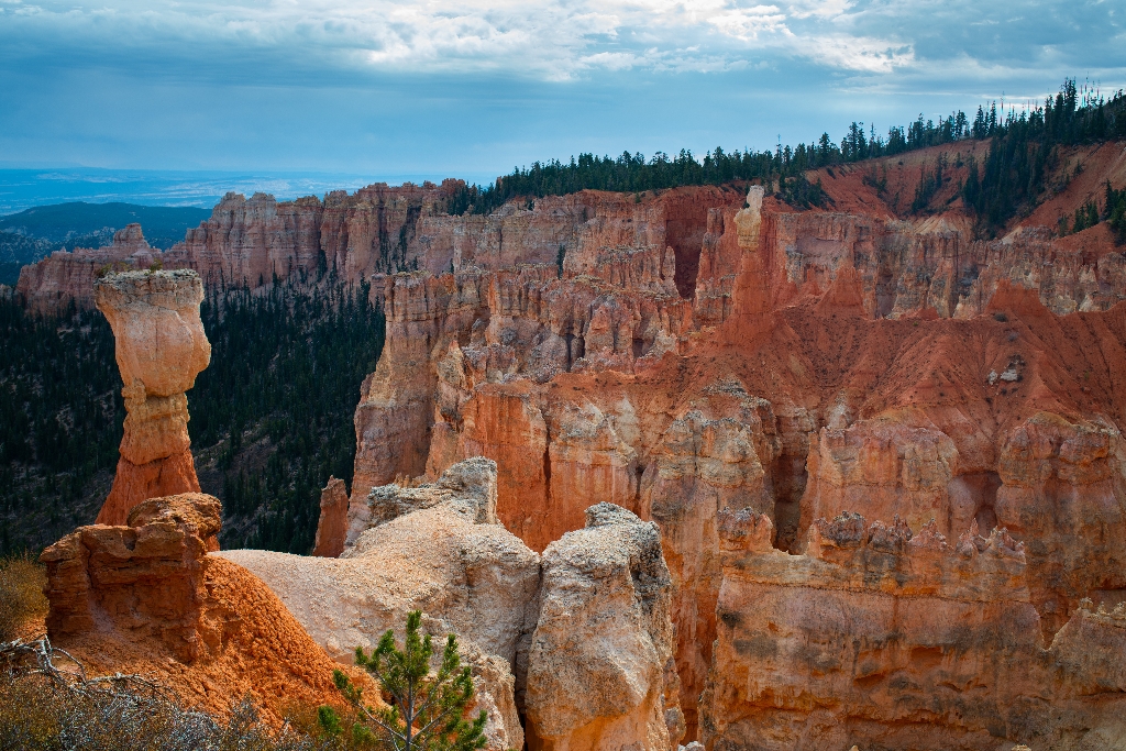
Tall, charismatic hoodoos are visible nearly at eye level from this view. These are created from the iron-rich mudstones and limestones of the park's Claron formation through repeated freeze/thaw cycles. Note the presence of limber pines (Pinus flexilis) atop the hoodoo known as "the Hunter", likely cached there as seeds by a Clark's nutcracker (Nucifraga columbiana).
The Paria Valley and the upper steps of the Grand Staircase exposed within it present most of the view beyond. Across the valley, the Table Cliff plateau stands at 10,000 feet (3048 m) and is composed of the same Claron formation (or "Pink Cliffs") as Bryce Canyon's hoodoos. This difference in elevation is due to the presence of the Paunsaugunt fault--a major normal fault that runs northeast to southwest along the park's eastern boundary. Uplift of the Colorado Plateau over the last 20 million years is responsible for the nearly 2,000 feet (607 m) of elevation difference expressed by this fault. Below these Pink Cliffs, observe the shale-rich badlands of the Grey Cliffs slowly transform to the sometimes iron-rich sandstones of the upper White Cliffs. Kodachrome State Park is located in this transition zone.
Almost the same distance to Navajo Mountain in the southeast, the Henry Mountains can be seen on days with good air quality, 86 miles (138 km) away beyond the eastern horizon. Like Navajo Mountain, these too are laccoliths--or plumes of molten rock that warped the rocks above them, but never broke through as a volcano would. As with the terrain of Capitol Reef National Park, which lies just in front of these peaks, millions of years of erosion have now occurred, and at the Henry Mountains it has removed the overlying rock and exposed the hard igneous cores within these mountains.
To the North
Observe the eroded edge of the Paunsaugunt Plateau, punctuated by bowl-shaped amphitheaters.
To the West
The rolling ponderosa forest of the Paunsaugunt plateau is deeply incised here by water travelling north to the Tropic Reservoir. The direction of flow is decided by the plateau's upward tilt to the south and has created a rain divide between the Great Basin of Nevada and the Colorado River that follows the edge of this plateau.
Is there something we missed for this itinerary?
Itineraries across USA


